San Juan Cosalá geodata
San Juan Cosalá (Jalisco) is a populated place; located in Mexico in America/Mexico_City (GMT-6) time zone. With population of 6,973 people, there are 1331 cities with bigger population in this country. Compared to other cities in Mexico, 63.3% of cities are located further ↓South; 87.4% of cities are located further →East and 52.7% of cities have lower elevation than San Juan Cosalá. Note1


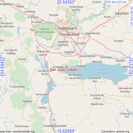
San Juan Cosalá GPS coordinates[2]
20° 17' 15.216" North, 103° 20' 27.924" West
| Map corner | latitude | longitude |
|---|---|---|
| Upper-left | 20.94565°, | -104.04422° |
| Center: | 20.28756°, | -103.34109° |
| Lower-right: | 19.62666°, | -102.63797° |
| Map W x H: | 146.7×146.7 km | = 91.2×91.2mi |
| max Lat: | 32.7° ⇑36.7% North |
| San Juan Cosalá: | 20.28756° |
| min Lat: | ⇓63.3% South 14.53588° |
| min Long | San Juan Cosal� | max Long |
| -117.105° | -103.34109° | -86.73105° |
| W 12.6%⇐ | ⇒87.4% E |
Elevation
Elevation of San Juan Cosalá is 1536 m = 5039 ft, and this is 282.3 m = 926 ft above average elevation for this country.
| Max E: |
3497 m = 11473 ft | 47.3% |
| San Juan Cosalá | 1536 m 5039 ft | |
| Avg. | 1253.7 m = 4113 ft | |
Min E: |
-1 m = -3 ft | 52.7% |
See also: Mexico elevation on elevation.city.
Geographical zone
San Juan Cosalá is located in North Torrid zone (between Equator and Tropic of Cancer). Distance of this Northern Tropic circle is 350.2 km =217.6 mi to North.| Distance of | km | miles | from San Juan Cosalá |
|---|---|---|---|
| North Pole | 7751.3 | 4816.4 | to North |
| Arctic Circle | 5145.4 | 3197.2 | to North |
| Tropic Cancer | 350.2 | 217.6 | to North |
| Equator | 2255.8 | 1401.7 | to South |


Nearby cities:
15 places around San Juan Cosalá: (largest is in red/bold)
• Ajijic
9.2 km =5.7 mi,  79°
79°
• Cajititlán
16.4 km =10.2 mi,  11°
11°
• Chapala
15.7 km =9.8 mi,  86°
86°
• Cuexcomatitlán
15.8 km =9.8 mi,  352°
352°
• Ixtlahuacán de los Membrillos
16.8 km =10.4 mi,  66°
66°
• Jocotepec
9.2 km =5.7 mi,  268°
268°
• Las Trojes
5.4 km =3.4 mi, 13°
• Los Cedros
16 km =9.9 mi,  44°
44°
• Potrerillos
6.8 km =4.2 mi,  326°
326°
• San Cristóbal Zapotitlán
7.6 km =4.7 mi,  203°
203°
• San Lucas Evangelista
13.6 km =8.5 mi, 351°
• San Luis Soyatlán
10.5 km =6.5 mi,  160°
160°
• San Miguel Cuyutlán
15.2 km =9.4 mi,  340°
340°
• San Pedro Tesistán
10.2 km =6.3 mi,  228°
228°
• Zapotitán de Hidalgo
15 km =9.3 mi,  286°
286°
Sources, notices
• [Note1] Compared only with cities in Mexico existing in our database
• [Src1] Map data: © OpenStreetMap contributors (CC-BY-SA)
• [Src2] Other city data from geonames.org with taken over terms of usage.
• [Src3] Geographical zone / Annual Mean Temperature by Robert A. Rohde @ Wikipedia
