Pátzcuaro geodata
Pátzcuaro (Michoacán) is a seat of a second-order administrative division; located in Mexico in America/Mexico_City (GMT-6) time zone. With population of 55,298 people, there are 205 cities with bigger population in this country. Compared to other cities in Mexico, 53.7% of cities are located further ↑North; 78.3% of cities are located further →East and 80.5% of cities have lower elevation than Pátzcuaro. Note1


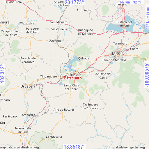
Pátzcuaro GPS coordinates[2]
19° 30' 57.384" North, 101° 36' 31.932" West
| Map corner | latitude | longitude |
|---|---|---|
| Upper-left | 20.1773°, | -102.312° |
| Center: | 19.51594°, | -101.60887° |
| Lower-right: | 18.85187°, | -100.90575° |
| Map W x H: | 147.4×147.4 km | = 91.6×91.6mi |
| max Lat: | 32.7° ⇑53.7% North |
| Pátzcuaro: | 19.51594° |
| min Lat: | ⇓46.3% South 14.53588° |
| min Long | Pátzcuaro | max Long |
| -117.105° | -101.60887° | -86.73105° |
| W 21.7%⇐ | ⇒78.3% E |
Elevation
Elevation of Pátzcuaro is 2153 m = 7064 ft, and this is 899.3 m = 2950 ft above average elevation for this country.
| Max E: |
3497 m = 11473 ft | 19.5% |
| Pátzcuaro | 2153 m 7064 ft | |
| Avg. | 1253.7 m = 4113 ft | |
Min E: |
-1 m = -3 ft | 80.5% |
See also: Pátzcuaro elevation on elevation.city.
Geographical zone
Pátzcuaro is located in North Torrid zone (between Equator and Tropic of Cancer). Distance of this Northern Tropic circle is 435.9 km =270.9 mi to North.| Distance of | km | miles | from Pátzcuaro |
|---|---|---|---|
| North Pole | 7837.1 | 4869.7 | to North |
| Arctic Circle | 5231.2 | 3250.5 | to North |
| Tropic Cancer | 435.9 | 270.9 | to North |
| Equator | 2170 | 1348.4 | to South |


Nearby cities:
15 places around Pátzcuaro: (largest is in red/bold)
• Arocutín
10.2 km =6.3 mi,  296°
296°
• Colonia Vista Bella (Lomas del Peaje)
3.2 km =2 mi,  150°
150°
• Cuanajo
11.1 km =6.9 mi,  108°
108°
• Cucuchucho
7.8 km =4.8 mi,  342°
342°
• Huecorio
3.6 km =2.2 mi,  314°
314°
• Ihuatzio
5.7 km =3.5 mi,  351°
351°
• Janitzio
7.8 km =4.8 mi,  324°
324°
• Jarácuaro
8.8 km =5.5 mi, 304°
• Joya de los Molinos
2.9 km =1.8 mi,  164°
164°
• San Miguel Charahuén
10.9 km =6.8 mi,  241°
241°
• San Miguel Nocutzepo
9.5 km =5.9 mi,  279°
279°
• San Pedro Pareo
6.7 km =4.2 mi,  285°
285°
• Santa Ana Chapitiro
4.7 km =2.9 mi, 283°
• Santa Juana
10.8 km =6.7 mi, 152°
• Tócuaro
9.4 km =5.8 mi, 286°
Sources, notices
• [Note1] Compared only with cities in Mexico existing in our database
• [Src1] Map data: © OpenStreetMap contributors (CC-BY-SA)
• [Src2] Other city data from geonames.org with taken over terms of usage.
• [Src3] Geographical zone / Annual Mean Temperature by Robert A. Rohde @ Wikipedia
