Huecorio geodata
Huecorio (Michoacán) is a populated place; located in Mexico in America/Mexico_City (GMT-6) time zone. With population of 832 people, there are 10517 cities with bigger population in this country. Compared to other cities in Mexico, 53.3% of cities are located further ↑North; 78.4% of cities are located further →East and 76.3% of cities have lower elevation than Huecorio. Note1


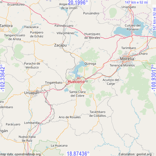
Huecorio GPS coordinates[2]
19° 32' 18.024" North, 101° 37' 59.844" West
| Map corner | latitude | longitude |
|---|---|---|
| Upper-left | 20.1996°, | -102.33642° |
| Center: | 19.53834°, | -101.63329° |
| Lower-right: | 18.87436°, | -100.93017° |
| Map W x H: | 147.4×147.4 km | = 91.6×91.6mi |
| max Lat: | 32.7° ⇑53.3% North |
| Huecorio: | 19.53834° |
| min Lat: | ⇓46.7% South 14.53588° |
| min Long | Huecorio | max Long |
| -117.105° | -101.63329° | -86.73105° |
| W 21.6%⇐ | ⇒78.4% E |
Elevation
Elevation of Huecorio is 2054 m = 6739 ft, and this is 800.3 m = 2626 ft above average elevation for this country.
| Max E: |
3497 m = 11473 ft | 23.7% |
| Huecorio | 2054 m 6739 ft | |
| Avg. | 1253.7 m = 4113 ft | |
Min E: |
-1 m = -3 ft | 76.3% |
See also: Mexico elevation on elevation.city.
Geographical zone
Huecorio is located in North Torrid zone (between Equator and Tropic of Cancer). Distance of this Northern Tropic circle is 433.5 km =269.4 mi to North.| Distance of | km | miles | from Huecorio |
|---|---|---|---|
| North Pole | 7834.6 | 4868.2 | to North |
| Arctic Circle | 5228.7 | 3249 | to North |
| Tropic Cancer | 433.5 | 269.4 | to North |
| Equator | 2172.5 | 1349.9 | to South |


Nearby cities:
15 places around Huecorio: (largest is in red/bold)
• Arocutín
6.9 km =4.3 mi,  287°
287°
• Colonia Vista Bella (Lomas del Peaje)
6.7 km =4.2 mi,  141°
141°
• Cucuchucho
4.9 km =3 mi,  2°
2°
• Ihuatzio
3.6 km =2.2 mi,  29°
29°
• Janitzio
4.3 km =2.7 mi,  333°
333°
• Jarácuaro
5.3 km =3.3 mi,  297°
297°
• Joya de los Molinos
6.2 km =3.9 mi,  147°
147°
• Napízaro
9.1 km =5.7 mi,  316°
316°
• Puácuaro
8.4 km =5.2 mi, 329°
• Pátzcuaro
3.6 km =2.2 mi,  134°
134°
• San Miguel Nocutzepo
6.9 km =4.3 mi,  262°
262°
• San Pedro Pareo
3.9 km =2.4 mi, 260°
• Santa Ana Chapitiro
2.4 km =1.5 mi,  235°
235°
• Tócuaro
6.4 km =4 mi,  271°
271°
• Uricho
9.4 km =5.8 mi, 292°
Sources, notices
• [Note1] Compared only with cities in Mexico existing in our database
• [Src1] Map data: © OpenStreetMap contributors (CC-BY-SA)
• [Src2] Other city data from geonames.org with taken over terms of usage.
• [Src3] Geographical zone / Annual Mean Temperature by Robert A. Rohde @ Wikipedia
