Paticajo geodata
Paticajo (Colima) is a populated place; located in Mexico in America/Mexico_City (GMT-6) time zone. With population of 718 people, there are 12143 cities with bigger population in this country. Compared to other cities in Mexico, 58.8% of cities are located further ↑North; 90.4% of cities are located further →East and 68.9% of cities have higher elevation than Paticajo. Note1


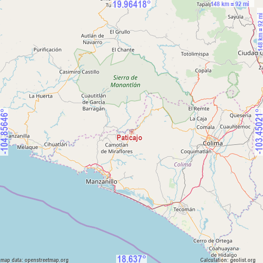
Paticajo GPS coordinates[2]
19° 18' 6.984" North, 104° 9' 11.988" West
| Map corner | latitude | longitude |
|---|---|---|
| Upper-left | 19.96418°, | -104.85646° |
| Center: | 19.30194°, | -104.15333° |
| Lower-right: | 18.637°, | -103.45021° |
| Map W x H: | 147.6×147.6 km | = 91.7×91.7mi |
| max Lat: | 32.7° ⇑58.8% North |
| Paticajo: | 19.30194° |
| min Lat: | ⇓41.2% South 14.53588° |
| min Long | Paticajo | max Long |
| -117.105° | -104.15333° | -86.73105° |
| W 9.6%⇐ | ⇒90.4% E |
Elevation
Elevation of Paticajo is 475 m = 1558 ft, and this is 778.7 m = 2555 ft below average elevation for this country.
| Max E: |
3497 m = 11473 ft | 68.9% |
| Avg. | 1253.7 m = 4113 ft | |
| Paticajo | 475 m = 1558 ft | |
Min E: |
-1 m = -3 ft | 31.1% |
See also: Mexico elevation on elevation.city.
Geographical zone
Paticajo is located in North Torrid zone (between Equator and Tropic of Cancer). Distance of this Northern Tropic circle is 459.7 km =285.6 mi to North.| Distance of | km | miles | from Paticajo |
|---|---|---|---|
| North Pole | 7860.9 | 4884.5 | to North |
| Arctic Circle | 5255 | 3265.3 | to North |
| Tropic Cancer | 459.7 | 285.6 | to North |
| Equator | 2146.2 | 1333.6 | to South |


Nearby cities:
15 places around Paticajo: (largest is in red/bold)
• Ayotitlán
19 km =11.8 mi,  350°
350°
• Benito Juárez de Peña Colorada (El Poblado)
9.3 km =5.8 mi,  43°
43°
• Camotlán de Miraflores
12.5 km =7.8 mi,  223°
223°
• Cedros
9.2 km =5.7 mi,  257°
257°
• Chacala
13.9 km =8.6 mi,  281°
281°
• Chandiablo
22.6 km =14 mi,  239°
239°
• Cuautitlán
27.3 km =17 mi,  307°
307°
• Cuzalapa
27.6 km =17.1 mi,  322°
322°
• El Chico
14.8 km =9.2 mi,  287°
287°
• Francisco Villa
24.2 km =15 mi,  207°
207°
• Jalipa
23.2 km =14.4 mi, 211°
• Minatitlán
11.6 km =7.2 mi,  51°
51°
• Minatitlán
14.4 km =8.9 mi, 48°
• Pueblo Juárez (La Magdalena)
27.7 km =17.2 mi,  122°
122°
• Telcruz
19.6 km =12.2 mi,  8°
8°
Sources, notices
• [Note1] Compared only with cities in Mexico existing in our database
• [Src1] Map data: © OpenStreetMap contributors (CC-BY-SA)
• [Src2] Other city data from geonames.org with taken over terms of usage.
• [Src3] Geographical zone / Annual Mean Temperature by Robert A. Rohde @ Wikipedia
