Camotlán de Miraflores geodata
Camotlán de Miraflores (Colima) is a populated place; located in Mexico in America/Mexico_City (GMT-6) time zone. With population of 1,778 people, there are 4883 cities with bigger population in this country. Compared to other cities in Mexico, 60.7% of cities are located further ↑North; 90.5% of cities are located further →East and 71.1% of cities have higher elevation than Camotlán de Miraflores. Note1
Current local time in Camotlán de Miraflores:
06:50 AM, WednesdayDifference from your time zone: hours


Camotlán de Miraflores GPS coordinates[2]
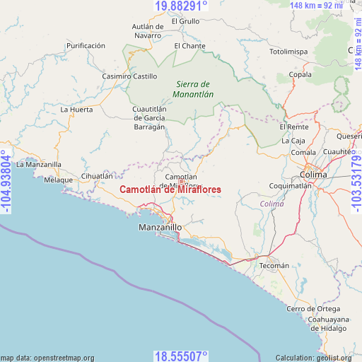
19° 13' 13.188" North, 104° 14' 5.676" West
| Map corner | latitude | longitude |
|---|---|---|
| Upper-left | 19.88291°, | -104.93804° |
| Center: | 19.22033°, | -104.23491° |
| Lower-right: | 18.55507°, | -103.53179° |
| Map W x H: | 147.6×147.6 km | = 91.7×91.7mi |
| max Lat: | 32.7° ⇑60.7% North |
| Camotlán de Miraflores: | 19.22033° |
| min Lat: | ⇓39.3% South 14.53588° |
| min Long | Camotlán de Mi | max Long |
| -117.105° | -104.23491° | -86.73105° |
| W 9.5%⇐ | ⇒90.5% E |
Elevation
Elevation of Camotlán de Miraflores is 367 m = 1204 ft, and this is 886.7 m = 2909 ft below average elevation for this country.
| Max E: |
3497 m = 11473 ft | 71.1% |
| Avg. | 1253.7 m = 4113 ft | |
| Camotlán de Miraflores | 367 m = 1204 ft | |
Min E: |
-1 m = -3 ft | 28.9% |
See also: Mexico elevation on elevation.city.
Geographical zone
Camotlán de Miraflores is located in North Torrid zone (between Equator and Tropic of Cancer). Distance of this Northern Tropic circle is 468.8 km =291.3 mi to North.| Distance of | km | miles | from Camotlán de Miraflores |
|---|---|---|---|
| North Pole | 7870 | 4890.2 | to North |
| Arctic Circle | 5264.1 | 3271 | to North |
| Tropic Cancer | 468.8 | 291.3 | to North |
| Equator | 2137.1 | 1327.9 | to South |


Nearby cities:
15 places around Camotlán de Miraflores: (largest is in red/bold)
• Benito Juárez de Peña Colorada (El Poblado)
21.8 km =13.5 mi,  43°
43°
• Cedros
7.1 km =4.4 mi,  356°
356°
• Chacala
12.9 km =8 mi,  336°
336°
• Chandiablo
11.2 km =7 mi,  257°
257°
• El Chico
14.7 km =9.1 mi, 337°
• El Colomo
17.9 km =11.1 mi,  187°
187°
• El Garcero
18.3 km =11.4 mi,  178°
178°
• El Naranjo
21.7 km =13.5 mi,  242°
242°
• Francisco Villa
12.7 km =7.9 mi, 192°
• Jalipa
11.4 km =7.1 mi,  197°
197°
• La Central
23 km =14.3 mi,  248°
248°
• Las Juntas (La Floreña)
18.4 km =11.4 mi, 176°
• Manzanillo
16.1 km =10 mi,  224°
224°
• Paticajo
12.5 km =7.8 mi, 43°
• Tapeixtles
17.6 km =10.9 mi, 196°
Sources, notices
• [Note1] Compared only with cities in Mexico existing in our database
• [Src1] Map data: © OpenStreetMap contributors (CC-BY-SA)
• [Src2] Other city data from geonames.org with taken over terms of usage.
• [Src3] Geographical zone / Annual Mean Temperature by Robert A. Rohde @ Wikipedia
