Páreo geodata
Páreo (Michoacán) is a populated place; located in Mexico in America/Mexico_City (GMT-6) time zone. With population of 1,981 people, there are 4398 cities with bigger population in this country. Compared to other cities in Mexico, 58% of cities are located further ↑North; 83.8% of cities are located further →East and 50% of cities have lower elevation than Páreo. Note1


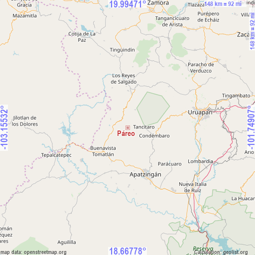
Páreo GPS coordinates[2]
19° 19' 57.324" North, 102° 27' 7.884" West
| Map corner | latitude | longitude |
|---|---|---|
| Upper-left | 19.99471°, | -103.15532° |
| Center: | 19.33259°, | -102.45219° |
| Lower-right: | 18.66778°, | -101.74907° |
| Map W x H: | 147.5×147.5 km | = 91.7×91.7mi |
| max Lat: | 32.7° ⇑58% North |
| Páreo: | 19.33259° |
| min Lat: | ⇓42% South 14.53588° |
| min Long | Páreo | max Long |
| -117.105° | -102.45219° | -86.73105° |
| W 16.2%⇐ | ⇒83.8% E |
Elevation
Elevation of Páreo is 1428 m = 4685 ft, and this is 174.3 m = 572 ft above average elevation for this country.
| Max E: |
3497 m = 11473 ft | 50% |
| Páreo | 1428 m 4685 ft | |
| Avg. | 1253.7 m = 4113 ft | |
Min E: |
-1 m = -3 ft | 50% |
See also: Mexico elevation on elevation.city.
Geographical zone
Páreo is located in North Torrid zone (between Equator and Tropic of Cancer). Distance of this Northern Tropic circle is 456.3 km =283.5 mi to North.| Distance of | km | miles | from Páreo |
|---|---|---|---|
| North Pole | 7857.5 | 4882.4 | to North |
| Arctic Circle | 5251.6 | 3263.2 | to North |
| Tropic Cancer | 456.3 | 283.5 | to North |
| Equator | 2149.6 | 1335.7 | to South |


Nearby cities:
15 places around Páreo: (largest is in red/bold)
• Agua Zarca
13.9 km =8.6 mi,  136°
136°
• Apo
11.4 km =7.1 mi,  22°
22°
• Apúndaro
3.2 km =2 mi,  50°
50°
• Araparícuaro (Aparícuaro)
17.7 km =11 mi,  91°
91°
• Buenavista Tomatlán
19.5 km =12.1 mi,  226°
226°
• Choritiro
7.5 km =4.7 mi,  56°
56°
• Condémbaro
16.2 km =10.1 mi,  105°
105°
• Los Fresnos
3.7 km =2.3 mi,  115°
115°
• Peribán de Ramos
21.2 km =13.2 mi,  10°
10°
• Santa Ana Amatlán
21.2 km =13.2 mi,  205°
205°
• Santa Catarina
7.3 km =4.5 mi,  129°
129°
• Tancítaro
9.4 km =5.8 mi, 86°
• Tazumbo
20.7 km =12.9 mi,  258°
258°
• Zirimbó
14.4 km =8.9 mi,  103°
103°
• Zirímondiro
11.5 km =7.1 mi,  78°
78°
Sources, notices
• [Note1] Compared only with cities in Mexico existing in our database
• [Src1] Map data: © OpenStreetMap contributors (CC-BY-SA)
• [Src2] Other city data from geonames.org with taken over terms of usage.
• [Src3] Geographical zone / Annual Mean Temperature by Robert A. Rohde @ Wikipedia
