Zirimbó geodata
Zirimbó (Michoacán) is a populated place; located in Mexico in America/Mexico_City (GMT-6) time zone. With population of 766 people, there are 11432 cities with bigger population in this country. Compared to other cities in Mexico, 58.8% of cities are located further ↑North; 83% of cities are located further →East and 72.6% of cities have lower elevation than Zirimbó. Note1


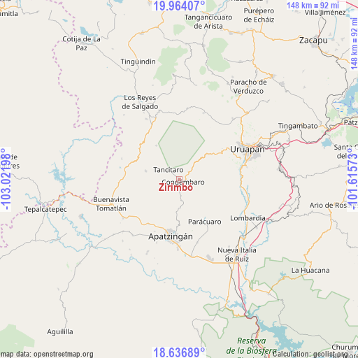
Zirimbó GPS coordinates[2]
19° 18' 6.588" North, 102° 19' 7.86" West
| Map corner | latitude | longitude |
|---|---|---|
| Upper-left | 19.96407°, | -103.02198° |
| Center: | 19.30183°, | -102.31885° |
| Lower-right: | 18.63689°, | -101.61573° |
| Map W x H: | 147.6×147.6 km | = 91.7×91.7mi |
| max Lat: | 32.7° ⇑58.8% North |
| Zirimbó: | 19.30183° |
| min Lat: | ⇓41.2% South 14.53588° |
| min Long | Zirimbó | max Long |
| -117.105° | -102.31885° | -86.73105° |
| W 17%⇐ | ⇒83% E |
Elevation
Elevation of Zirimbó is 1979 m = 6493 ft, and this is 725.3 m = 2380 ft above average elevation for this country.
| Max E: |
3497 m = 11473 ft | 27.4% |
| Zirimbó | 1979 m 6493 ft | |
| Avg. | 1253.7 m = 4113 ft | |
Min E: |
-1 m = -3 ft | 72.6% |
See also: Mexico elevation on elevation.city.
Geographical zone
Zirimbó is located in North Torrid zone (between Equator and Tropic of Cancer). Distance of this Northern Tropic circle is 459.8 km =285.7 mi to North.| Distance of | km | miles | from Zirimbó |
|---|---|---|---|
| North Pole | 7860.9 | 4884.5 | to North |
| Arctic Circle | 5255 | 3265.3 | to North |
| Tropic Cancer | 459.8 | 285.7 | to North |
| Equator | 2146.2 | 1333.6 | to South |


Nearby cities:
15 places around Zirimbó: (largest is in red/bold)
• Agua Zarca
8.1 km =5 mi,  213°
213°
• Apo
17 km =10.6 mi,  325°
325°
• Apúndaro
12.8 km =8 mi,  295°
295°
• Araparícuaro (Aparícuaro)
4.7 km =2.9 mi,  51°
51°
• Choritiro
10.9 km =6.8 mi,  314°
314°
• Condémbaro
1.8 km =1.1 mi,  122°
122°
• Cutzato (Cuisato)
20.6 km =12.8 mi,  69°
69°
• La Estancia
17.9 km =11.1 mi, 124°
• Los Bancos
17.7 km =11 mi,  138°
138°
• Los Fresnos
10.8 km =6.7 mi,  279°
279°
• Paracuaro
20 km =12.4 mi,  148°
148°
• Páreo
14.4 km =8.9 mi, 283°
• Santa Catarina
8.5 km =5.3 mi,  261°
261°
• Tancítaro
6.1 km =3.8 mi, 311°
• Zirímondiro
6.3 km =3.9 mi, 334°
Sources, notices
• [Note1] Compared only with cities in Mexico existing in our database
• [Src1] Map data: © OpenStreetMap contributors (CC-BY-SA)
• [Src2] Other city data from geonames.org with taken over terms of usage.
• [Src3] Geographical zone / Annual Mean Temperature by Robert A. Rohde @ Wikipedia
