Palmar Chico geodata
Palmar Chico (State of Mexico) is a populated place; located in Mexico in America/Mexico_City (GMT-6) time zone. With population of 3,127 people, there are 2887 cities with bigger population in this country. Compared to other cities in Mexico, 70.3% of cities are located further ↑North; 68.1% of cities are located further →East and 63.4% of cities have higher elevation than Palmar Chico. Note1


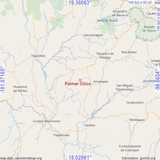
Palmar Chico GPS coordinates[2]
18° 41' 45.348" North, 100° 22' 6.672" West
| Map corner | latitude | longitude |
|---|---|---|
| Upper-left | 19.36063°, | -101.07165° |
| Center: | 18.69593°, | -100.36852° |
| Lower-right: | 18.02861°, | -99.6654° |
| Map W x H: | 148.1×148.1 km | = 92×92mi |
| max Lat: | 32.7° ⇑70.3% North |
| Palmar Chico: | 18.69593° |
| min Lat: | ⇓29.7% South 14.53588° |
| min Long | Palmar Chico | max Long |
| -117.105° | -100.36852° | -86.73105° |
| W 31.9%⇐ | ⇒68.1% E |
Elevation
Elevation of Palmar Chico is 789 m = 2589 ft, and this is 464.7 m = 1525 ft below average elevation for this country.
| Max E: |
3497 m = 11473 ft | 63.4% |
| Avg. | 1253.7 m = 4113 ft | |
| Palmar Chico | 789 m = 2589 ft | |
Min E: |
-1 m = -3 ft | 36.6% |
See also: Mexico elevation on elevation.city.
Geographical zone
Palmar Chico is located in North Torrid zone (between Equator and Tropic of Cancer). Distance of this Northern Tropic circle is 527.1 km =327.5 mi to North.| Distance of | km | miles | from Palmar Chico |
|---|---|---|---|
| North Pole | 7928.3 | 4926.4 | to North |
| Arctic Circle | 5322.4 | 3307.2 | to North |
| Tropic Cancer | 527.1 | 327.5 | to North |
| Equator | 2078.8 | 1291.7 | to South |


Nearby cities:
15 places around Palmar Chico: (largest is in red/bold)
• Amatepec
19.3 km =12 mi,  94°
94°
• Balderrama
19 km =11.8 mi,  281°
281°
• Bejucos
11.1 km =6.9 mi,  325°
325°
• Cañadas de Nanchititla
20.6 km =12.8 mi,  335°
335°
• Cerro del Campo
11.8 km =7.3 mi,  108°
108°
• El Rancho
9.6 km =6 mi,  100°
100°
• Mayaltepec
12.6 km =7.8 mi,  180°
180°
• Palmar Grande
13.4 km =8.3 mi,  198°
198°
• San Francisco de Asís
12.1 km =7.5 mi,  129°
129°
• San Juan Tetitlán
20.3 km =12.6 mi,  118°
118°
• San Pedro Limón
14.2 km =8.8 mi,  152°
152°
• San Simón
21.2 km =13.2 mi,  74°
74°
• Santa Ana Zicatecoyan
20.9 km =13 mi, 131°
• Tlacocuspan
10 km =6.2 mi, 148°
• Tlatlaya
19 km =11.8 mi, 117°
Sources, notices
• [Note1] Compared only with cities in Mexico existing in our database
• [Src1] Map data: © OpenStreetMap contributors (CC-BY-SA)
• [Src2] Other city data from geonames.org with taken over terms of usage.
• [Src3] Geographical zone / Annual Mean Temperature by Robert A. Rohde @ Wikipedia
