Palmar Grande geodata
Palmar Grande (State of Mexico) is a populated place; located in Mexico in America/Mexico_City (GMT-6) time zone. With population of 656 people, there are 13229 cities with bigger population in this country. Compared to other cities in Mexico, 71.6% of cities are located further ↑North; 68.6% of cities are located further →East and 65.5% of cities have higher elevation than Palmar Grande. Note1


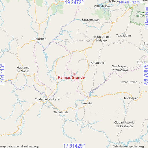
Palmar Grande GPS coordinates[2]
18° 34' 55.38" North, 100° 24' 35.532" West
| Map corner | latitude | longitude |
|---|---|---|
| Upper-left | 19.2472°, | -101.113° |
| Center: | 18.58205°, | -100.40987° |
| Lower-right: | 17.91429°, | -99.70675° |
| Map W x H: | 148.2×148.2 km | = 92.1×92.1mi |
| max Lat: | 32.7° ⇑71.6% North |
| Palmar Grande: | 18.58205° |
| min Lat: | ⇓28.4% South 14.53588° |
| min Long | Palmar Grande | max Long |
| -117.105° | -100.40987° | -86.73105° |
| W 31.4%⇐ | ⇒68.6% E |
Elevation
Elevation of Palmar Grande is 663 m = 2175 ft, and this is 590.7 m = 1938 ft below average elevation for this country.
| Max E: |
3497 m = 11473 ft | 65.5% |
| Avg. | 1253.7 m = 4113 ft | |
| Palmar Grande | 663 m = 2175 ft | |
Min E: |
-1 m = -3 ft | 34.5% |
See also: Mexico elevation on elevation.city.
Geographical zone
Palmar Grande is located in North Torrid zone (between Equator and Tropic of Cancer). Distance of this Northern Tropic circle is 539.8 km =335.4 mi to North.| Distance of | km | miles | from Palmar Grande |
|---|---|---|---|
| North Pole | 7940.9 | 4934.2 | to North |
| Arctic Circle | 5335 | 3315 | to North |
| Tropic Cancer | 539.8 | 335.4 | to North |
| Equator | 2066.1 | 1283.8 | to South |


Nearby cities:
15 places around Palmar Grande: (largest is in red/bold)
• Balderrama
21.7 km =13.5 mi,  319°
319°
• Cerro del Campo
18 km =11.2 mi,  59°
59°
• El Rancho
17.7 km =11 mi,  51°
51°
• El Salitre (Sirapitiro)
18.2 km =11.3 mi,  274°
274°
• Mayaltepec
4.2 km =2.6 mi,  89°
89°
• Otlatepec (Agua del Padre)
12.4 km =7.7 mi,  229°
229°
• Palmar Chico
13.4 km =8.3 mi,  18°
18°
• Rincón Grande
16.3 km =10.1 mi,  156°
156°
• San Francisco de Asís
14.5 km =9 mi,  70°
70°
• San Pedro Limón
10.8 km =6.7 mi, 90°
• Santa Ana Zicatecoyan
20 km =12.4 mi, 93°
• Tlacocuspan
10.4 km =6.5 mi, 66°
• Tlalchapa
20.3 km =12.6 mi,  200°
200°
• Tlatlaya
21.7 km =13.5 mi,  79°
79°
• Villa Madero
19.4 km =12.1 mi,  192°
192°
Sources, notices
• [Note1] Compared only with cities in Mexico existing in our database
• [Src1] Map data: © OpenStreetMap contributors (CC-BY-SA)
• [Src2] Other city data from geonames.org with taken over terms of usage.
• [Src3] Geographical zone / Annual Mean Temperature by Robert A. Rohde @ Wikipedia
