Maruata geodata
Maruata (Michoacán) is a populated place; located in Mexico in America/Mexico_City (GMT-6) time zone. With population of 590 people, there are 14554 cities with bigger population in this country. Compared to other cities in Mexico, 75.3% of cities are located further ↑North; 87.5% of cities are located further →East and 91.6% of cities have higher elevation than Maruata. Note1


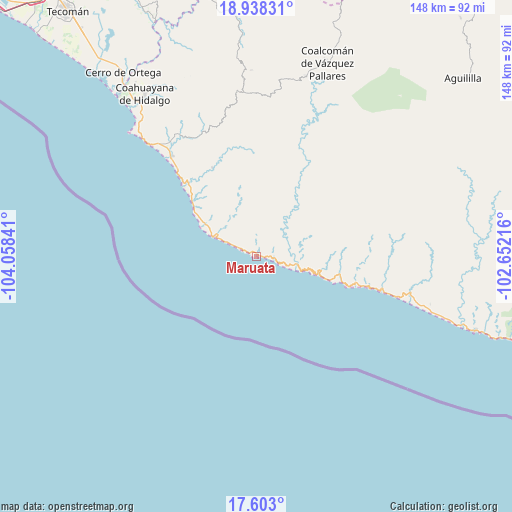
Maruata GPS coordinates[2]
18° 16' 18.984" North, 103° 21' 19.008" West
| Map corner | latitude | longitude |
|---|---|---|
| Upper-left | 18.93831°, | -104.05841° |
| Center: | 18.27194°, | -103.35528° |
| Lower-right: | 17.603°, | -102.65216° |
| Map W x H: | 148.5×148.5 km | = 92.3×92.3mi |
| max Lat: | 32.7° ⇑75.3% North |
| Maruata: | 18.27194° |
| min Lat: | ⇓24.7% South 14.53588° |
| min Long | Maruata | max Long |
| -117.105° | -103.35528° | -86.73105° |
| W 12.5%⇐ | ⇒87.5% E |
Elevation
Elevation of Maruata is 20 m = 66 ft, and this is 1233.7 m = 4048 ft below average elevation for this country.
| Max E: |
3497 m = 11473 ft | 91.6% |
| Avg. | 1253.7 m = 4113 ft | |
| Maruata | 20 m = 66 ft | |
Min E: |
-1 m = -3 ft | 8.4% |
See also: Mexico elevation on elevation.city.
Geographical zone
Maruata is located in North Torrid zone (between Equator and Tropic of Cancer). Distance of this Northern Tropic circle is 574.3 km =356.9 mi to North.| Distance of | km | miles | from Maruata |
|---|---|---|---|
| North Pole | 7975.4 | 4955.7 | to North |
| Arctic Circle | 5369.5 | 3336.5 | to North |
| Tropic Cancer | 574.3 | 356.9 | to North |
| Equator | 2031.6 | 1262.4 | to South |


Nearby cities:
15 places around Maruata: (largest is in red/bold)
• Aguililla
79 km =49.1 mi,  49°
49°
• Aquila
39.7 km =24.7 mi,  336°
336°
• Cerro de Ortega
65.8 km =40.9 mi,  324°
324°
• Coahuayana Viejo
62.7 km =39 mi,  328°
328°
• Coahuayana de Hidalgo
57.7 km =35.9 mi, 325°
• Coalcomán de Vázquez Pallares
59.9 km =37.2 mi,  20°
20°
• Colola
6.5 km =4 mi,  295°
295°
• Colonia Veinte de Noviembre (El Camalote)
62.3 km =38.7 mi, 332°
• Dos Aguas
74.7 km =46.4 mi,  37°
37°
• La Placita de Morelos
38 km =23.6 mi, 319°
• La Ticla
29.3 km =18.2 mi,  313°
313°
• San Pedro Naranjestil
23.7 km =14.7 mi,  82°
82°
• Santa María de Ostula
28.8 km =17.9 mi, 333°
• Villa Victoria
54 km =33.6 mi,  358°
358°
• Zapotán
55.1 km =34.2 mi, 332°
Sources, notices
• [Note1] Compared only with cities in Mexico existing in our database
• [Src1] Map data: © OpenStreetMap contributors (CC-BY-SA)
• [Src2] Other city data from geonames.org with taken over terms of usage.
• [Src3] Geographical zone / Annual Mean Temperature by Robert A. Rohde @ Wikipedia
