Ojinaga geodata
Ojinaga (Chihuahua) is a populated place; located in Mexico in America/Ojinaga (GMT-5) time zone. With population of 22,128 people, there are 465 cities with bigger population in this country. Compared to other cities in Mexico, 98.3% of cities are located further ↓South; 91.1% of cities are located further →East and 63.2% of cities have higher elevation than Ojinaga. Note1


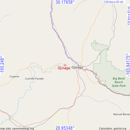
Ojinaga GPS coordinates[2]
29° 34' 0.804" North, 104° 32' 41.532" West
| Map corner | latitude | longitude |
|---|---|---|
| Upper-left | 30.17659°, | -105.248° |
| Center: | 29.56689°, | -104.54487° |
| Lower-right: | 28.95348°, | -103.84175° |
| Map W x H: | 136×136 km | = 84.5×84.5mi |
| max Lat: | 32.7° ⇑1.7% North |
| Ojinaga: | 29.56689° |
| min Lat: | ⇓98.3% South 14.53588° |
| min Long | Ojinaga | max Long |
| -117.105° | -104.54487° | -86.73105° |
| W 8.9%⇐ | ⇒91.1% E |
Elevation
Elevation of Ojinaga is 805 m = 2641 ft, and this is 448.7 m = 1472 ft below average elevation for this country.
| Max E: |
3497 m = 11473 ft | 63.2% |
| Avg. | 1253.7 m = 4113 ft | |
| Ojinaga | 805 m = 2641 ft | |
Min E: |
-1 m = -3 ft | 36.8% |
See also: Mexico elevation on elevation.city.
Geographical zone
Ojinaga is located in North temperate zone (between Tropic of Cancer and the Arctic Circle). Distance of this Northern Tropic circle is 681.6 km =423.5 mi to South.| Distance of | km | miles | from Ojinaga |
|---|---|---|---|
| North Pole | 6719.5 | 4175.3 | to North |
| Arctic Circle | 4113.6 | 2556.1 | to North |
| Tropic Cancer | 681.6 | 423.5 | to South |
| Equator | 3287.5 | 2042.8 | to South |


Nearby cities:
15 places around Ojinaga: (largest is in red/bold)
• Aldama
155.7 km =96.7 mi,  238°
238°
• Colonia Esperanza
152.7 km =94.9 mi,  215°
215°
• Colonia Felipe Ángeles
161.6 km =100.4 mi, 215°
• Colonia San José
157.8 km =98.1 mi,  213°
213°
• Coyame
54.4 km =33.8 mi,  257°
257°
• El Torreón
161.8 km =100.5 mi, 211°
• Jiménez
160.4 km =99.7 mi, 211°
• Julimes
153.4 km =95.3 mi, 214°
• La Perla
140.2 km =87.1 mi,  180°
180°
• La Regina
155.9 km =96.9 mi, 214°
• Los García
159.8 km =99.3 mi, 212°
• Manuel Benavides
80.3 km =49.9 mi,  129°
129°
• Manuel Ojinaga
12.4 km =7.7 mi,  91°
91°
• Salón de Actos (Ampliación Cuarenta y Siete)
153.8 km =95.6 mi, 219°
• San Carlos
80.2 km =49.8 mi, 129°
Sources, notices
• [Note1] Compared only with cities in Mexico existing in our database
• [Src1] Map data: © OpenStreetMap contributors (CC-BY-SA)
• [Src2] Other city data from geonames.org with taken over terms of usage.
• [Src3] Geographical zone / Annual Mean Temperature by Robert A. Rohde @ Wikipedia
