Milpillas geodata
Milpillas (Sonora) is a populated place; located in Mexico in America/Chihuahua (GMT-6) time zone. With population of 1,025 people, there are 8501 cities with bigger population in this country. Compared to other cities in Mexico, 96.6% of cities are located further ↓South; 96.5% of cities are located further →East and 51% of cities have higher elevation than Milpillas. Note1


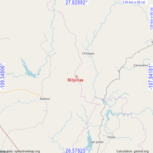
Milpillas GPS coordinates[2]
27° 12' 19.224" North, 108° 38' 41.748" West
| Map corner | latitude | longitude |
|---|---|---|
| Upper-left | 27.82892°, | -109.34806° |
| Center: | 27.20534°, | -108.64493° |
| Lower-right: | 26.57825°, | -107.94181° |
| Map W x H: | 139.1×139.1 km | = 86.4×86.4mi |
| max Lat: | 32.7° ⇑3.4% North |
| Milpillas: | 27.20534° |
| min Lat: | ⇓96.6% South 14.53588° |
| min Long | Milpillas | max Long |
| -117.105° | -108.64493° | -86.73105° |
| W 3.5%⇐ | ⇒96.5% E |
Elevation
Elevation of Milpillas is 1380 m = 4528 ft, and this is 126.3 m = 414 ft above average elevation for this country.
| Max E: |
3497 m = 11473 ft | 51% |
| Milpillas | 1380 m 4528 ft | |
| Avg. | 1253.7 m = 4113 ft | |
Min E: |
-1 m = -3 ft | 49% |
See also: Mexico elevation on elevation.city.
Geographical zone
Milpillas is located in North temperate zone (between Tropic of Cancer and the Arctic Circle). Distance of this Northern Tropic circle is 419 km =260.4 mi to South.| Distance of | km | miles | from Milpillas |
|---|---|---|---|
| North Pole | 6982.1 | 4338.5 | to North |
| Arctic Circle | 4376.2 | 2719.2 | to North |
| Tropic Cancer | 419 | 260.4 | to South |
| Equator | 3025 | 1879.6 | to South |


Nearby cities:
15 places around Milpillas: (largest is in red/bold)
• Bahuichivo
61.4 km =38.2 mi,  68°
68°
• Bajosori
62.8 km =39 mi,  156°
156°
• Cerocahui
59.2 km =36.8 mi,  79°
79°
• Choix
63.6 km =39.5 mi,  150°
150°
• Chínipas
23.6 km =14.7 mi,  26°
26°
• El Mocúzarit (Conicárit)
44.7 km =27.8 mi,  271°
271°
• Guadalupe
72.5 km =45 mi, 153°
• Los Tanques
24.7 km =15.3 mi, 271°
• Quiriego
69.4 km =43.1 mi,  300°
300°
• San Bernardo
29.2 km =18.1 mi,  317°
317°
• San Javier
62 km =38.5 mi, 162°
• Tierra Blanca
69.3 km =43.1 mi, 268°
• Témoris
37 km =23 mi, 77°
• Urique
72.3 km =44.9 mi,  89°
89°
• Álamos
35.1 km =21.8 mi,  234°
234°
Sources, notices
• [Note1] Compared only with cities in Mexico existing in our database
• [Src1] Map data: © OpenStreetMap contributors (CC-BY-SA)
• [Src2] Other city data from geonames.org with taken over terms of usage.
• [Src3] Geographical zone / Annual Mean Temperature by Robert A. Rohde @ Wikipedia
