Urique geodata
Urique (Chihuahua) is a seat of a second-order administrative division; located in Mexico in America/Chihuahua (GMT-6) time zone. With population of 1,102 people, there are 7894 cities with bigger population in this country. Compared to other cities in Mexico, 96.6% of cities are located further ↓South; 95.5% of cities are located further →East and 67.5% of cities have higher elevation than Urique. Note1


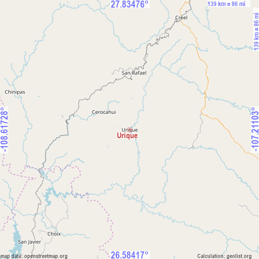
Urique GPS coordinates[2]
27° 12' 40.392" North, 107° 54' 50.94" West
| Map corner | latitude | longitude |
|---|---|---|
| Upper-left | 27.83476°, | -108.61728° |
| Center: | 27.21122°, | -107.91415° |
| Lower-right: | 26.58417°, | -107.21103° |
| Map W x H: | 139.1×139.1 km | = 86.4×86.4mi |
| max Lat: | 32.7° ⇑3.4% North |
| Urique: | 27.21122° |
| min Lat: | ⇓96.6% South 14.53588° |
| min Long | Urique | max Long |
| -117.105° | -107.91415° | -86.73105° |
| W 4.5%⇐ | ⇒95.5% E |
Elevation
Elevation of Urique is 551 m = 1808 ft, and this is 702.7 m = 2305 ft below average elevation for this country.
| Max E: |
3497 m = 11473 ft | 67.5% |
| Avg. | 1253.7 m = 4113 ft | |
| Urique | 551 m = 1808 ft | |
Min E: |
-1 m = -3 ft | 32.5% |
See also: Mexico elevation on elevation.city.
Geographical zone
Urique is located in North temperate zone (between Tropic of Cancer and the Arctic Circle). Distance of this Northern Tropic circle is 419.7 km =260.8 mi to South.| Distance of | km | miles | from Urique |
|---|---|---|---|
| North Pole | 6981.5 | 4338.1 | to North |
| Arctic Circle | 4375.6 | 2718.9 | to North |
| Tropic Cancer | 419.7 | 260.8 | to South |
| Equator | 3025.6 | 1880 | to South |


Nearby cities:
15 places around Urique: (largest is in red/bold)
• Bahuichivo
26.7 km =16.6 mi,  325°
325°
• Batopilas
26.6 km =16.5 mi,  139°
139°
• Cerocahui
17 km =10.6 mi,  305°
305°
• Choix
69.1 km =42.9 mi,  216°
216°
• Chínipas
64.9 km =40.3 mi,  288°
288°
• Creel
66 km =41 mi,  24°
24°
• Guapalaina
4.2 km =2.6 mi,  152°
152°
• Maguarichi
72.5 km =45 mi,  353°
353°
• Milpillas
72.3 km =44.9 mi,  269°
269°
• Morelos
64.3 km =40 mi,  158°
158°
• Polanco (Ranchería Mineral Polanco)
50.2 km =31.2 mi, 146°
• Samachique
38.4 km =23.9 mi,  74°
74°
• San Rafael
31.9 km =19.8 mi,  4°
4°
• Témoris
36.8 km =22.9 mi,  281°
281°
• Yoquivo
42.9 km =26.7 mi,  118°
118°
Sources, notices
• [Note1] Compared only with cities in Mexico existing in our database
• [Src1] Map data: © OpenStreetMap contributors (CC-BY-SA)
• [Src2] Other city data from geonames.org with taken over terms of usage.
• [Src3] Geographical zone / Annual Mean Temperature by Robert A. Rohde @ Wikipedia
