Choix geodata
Choix (Sinaloa) is a populated place; located in Mexico in America/Mazatlan (GMT-7) time zone. With population of 9,306 people, there are 1020 cities with bigger population in this country. Compared to other cities in Mexico, 95.9% of cities are located further ↓South; 96% of cities are located further →East and 74.4% of cities have higher elevation than Choix. Note1


Choix GPS coordinates[2]
26° 42' 32.436" North, 108° 19' 31.62" West
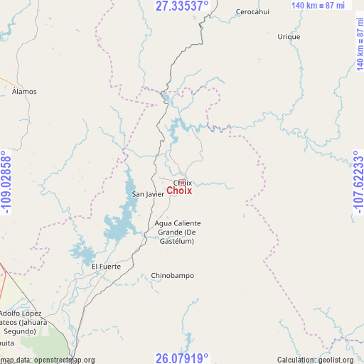
| Map corner | latitude | longitude |
|---|---|---|
| Upper-left | 27.33537°, | -109.02858° |
| Center: | 26.70901°, | -108.32545° |
| Lower-right: | 26.07919°, | -107.62233° |
| Map W x H: | 139.7×139.7 km | = 86.8×86.8mi |
| max Lat: | 32.7° ⇑4.1% North |
| Choix: | 26.70901° |
| min Lat: | ⇓95.9% South 14.53588° |
| min Long | Choix | max Long |
| -117.105° | -108.32545° | -86.73105° |
| W 4%⇐ | ⇒96% E |
Elevation
Elevation of Choix is 240 m = 787 ft, and this is 1013.7 m = 3326 ft below average elevation for this country.
| Max E: |
3497 m = 11473 ft | 74.4% |
| Avg. | 1253.7 m = 4113 ft | |
| Choix | 240 m = 787 ft | |
Min E: |
-1 m = -3 ft | 25.6% |
See also: Mexico elevation on elevation.city.
Geographical zone
Choix is located in North temperate zone (between Tropic of Cancer and the Arctic Circle). Distance of this Northern Tropic circle is 363.8 km =226.1 mi to South.| Distance of | km | miles | from Choix |
|---|---|---|---|
| North Pole | 7037.3 | 4372.8 | to North |
| Arctic Circle | 4431.4 | 2753.5 | to North |
| Tropic Cancer | 363.8 | 226.1 | to South |
| Equator | 2969.8 | 1845.3 | to South |


Nearby cities:
15 places around Choix: (largest is in red/bold)
• Agua Caliente Grande (De Gastélum)
19.2 km =11.9 mi,  186°
186°
• Bajosori
7.2 km =4.5 mi,  250°
250°
• Baroten
47.3 km =29.4 mi,  223°
223°
• Boca de Arroyo
61 km =37.9 mi, 224°
• Chinobampo
35.7 km =22.2 mi, 186°
• El Canutillo
47.7 km =29.6 mi, 218°
• El Fuerte
43.6 km =27.1 mi, 221°
• Estación Hoyancos (Estación el Fuerte)
46.4 km =28.8 mi, 215°
• Guadalupe
9.8 km =6.1 mi,  176°
176°
• La Bajada del Monte
55.7 km =34.6 mi, 222°
• Los Capomos
36.9 km =22.9 mi,  210°
210°
• San Javier
13.9 km =8.6 mi, 253°
• San Pedro
25.4 km =15.8 mi, 215°
• Santa Ana
14.5 km =9 mi,  203°
203°
• Tehueco
62.1 km =38.6 mi, 222°
Sources, notices
• [Note1] Compared only with cities in Mexico existing in our database
• [Src1] Map data: © OpenStreetMap contributors (CC-BY-SA)
• [Src2] Other city data from geonames.org with taken over terms of usage.
• [Src3] Geographical zone / Annual Mean Temperature by Robert A. Rohde @ Wikipedia
