San Miguel Zapotitlán geodata
San Miguel Zapotitlán (Jalisco) is a populated place; located in Mexico in America/Mexico_City (GMT-6) time zone. With population of 2,225 people, there are 3943 cities with bigger population in this country. Compared to other cities in Mexico, 65.4% of cities are located further ↓South; 85.7% of cities are located further →East and 52.8% of cities have lower elevation than San Miguel Zapotitlán. Note1
Current local time in San Miguel Zapotitlán:
12:46 AM, WednesdayDifference from your time zone: hours


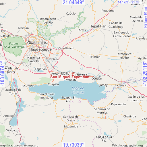
San Miguel Zapotitlán GPS coordinates[2]
20° 23' 27.06" North, 102° 59' 39.408" West
| Map corner | latitude | longitude |
|---|---|---|
| Upper-left | 21.04849°, | -103.69741° |
| Center: | 20.39085°, | -102.99428° |
| Lower-right: | 19.73039°, | -102.29116° |
| Map W x H: | 146.6×146.6 km | = 91.1×91.1mi |
| max Lat: | 32.7° ⇑34.6% North |
| San Miguel Zapotitlán: | 20.39085° |
| min Lat: | ⇓65.4% South 14.53588° |
| min Long | San Miguel Zapo | max Long |
| -117.105° | -102.99428° | -86.73105° |
| W 14.3%⇐ | ⇒85.7% E |
Elevation
Elevation of San Miguel Zapotitlán is 1537 m = 5043 ft, and this is 283.3 m = 929 ft above average elevation for this country.
| Max E: |
3497 m = 11473 ft | 47.2% |
| San Miguel Zapotitlán | 1537 m 5043 ft | |
| Avg. | 1253.7 m = 4113 ft | |
Min E: |
-1 m = -3 ft | 52.8% |
See also: Mexico elevation on elevation.city.
Geographical zone
San Miguel Zapotitlán is located in North Torrid zone (between Equator and Tropic of Cancer). Distance of this Northern Tropic circle is 338.7 km =210.5 mi to North.| Distance of | km | miles | from San Miguel Zapotitlán |
|---|---|---|---|
| North Pole | 7739.8 | 4809.3 | to North |
| Arctic Circle | 5133.9 | 3190.1 | to North |
| Tropic Cancer | 338.7 | 210.5 | to North |
| Equator | 2267.2 | 1408.8 | to South |


Nearby cities:
15 places around San Miguel Zapotitlán: (largest is in red/bold)
• Ahuatlán
11.5 km =7.1 mi,  74°
74°
• Atotonilquillo
13.5 km =8.4 mi,  270°
270°
• Chalpicote
12.2 km =7.6 mi,  137°
137°
• Chila
8.2 km =5.1 mi,  17°
17°
• El Romereño (INFONAVIT)
4.8 km =3 mi,  103°
103°
• La Colonia
7.8 km =4.8 mi,  58°
58°
• La Zapotera
13.8 km =8.6 mi,  133°
133°
• Mezcala
6.6 km =4.1 mi,  201°
201°
• Poncitlán
7.3 km =4.5 mi, 99°
• San Jacinto
6.6 km =4.1 mi,  277°
277°
• San Juan Tecomatlán
13.1 km =8.1 mi,  237°
237°
• San Pedro Itzicán
9.2 km =5.7 mi,  152°
152°
• Santa Cruz el Grande
13.7 km =8.5 mi, 97°
• Tecualtitán
5.2 km =3.2 mi,  317°
317°
• Zapotlán del Rey
11 km =6.8 mi,  40°
40°
Sources, notices
• [Note1] Compared only with cities in Mexico existing in our database
• [Src1] Map data: © OpenStreetMap contributors (CC-BY-SA)
• [Src2] Other city data from geonames.org with taken over terms of usage.
• [Src3] Geographical zone / Annual Mean Temperature by Robert A. Rohde @ Wikipedia
