El Romereño (INFONAVIT) geodata
El Romereño (INFONAVIT) (Jalisco) is a populated place; located in Mexico in America/Mexico_City (GMT-6) time zone. With population of 2,182 people, there are 4027 cities with bigger population in this country. Compared to other cities in Mexico, 65.2% of cities are located further ↓South; 85.6% of cities are located further →East and 52.9% of cities have lower elevation than El Romereño (INFONAVIT). Note1
Current local time in El Romereño (INFONAVIT):
05:20 AM, WednesdayDifference from your time zone: hours


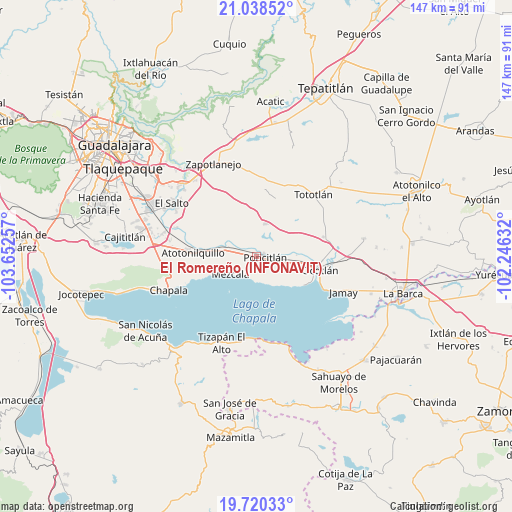
El Romereño (INFONAVIT) GPS coordinates[2]
20° 22' 50.988" North, 102° 56' 57.984" West
| Map corner | latitude | longitude |
|---|---|---|
| Upper-left | 21.03852°, | -103.65257° |
| Center: | 20.38083°, | -102.94944° |
| Lower-right: | 19.72033°, | -102.24632° |
| Map W x H: | 146.6×146.6 km | = 91.1×91.1mi |
| max Lat: | 32.7° ⇑34.8% North |
| El Romereño (INFONAVIT): | 20.38083° |
| min Lat: | ⇓65.2% South 14.53588° |
| min Long | El Romereño (I | max Long |
| -117.105° | -102.94944° | -86.73105° |
| W 14.4%⇐ | ⇒85.6% E |
Elevation
Elevation of El Romereño (INFONAVIT) is 1540 m = 5052 ft, and this is 286.3 m = 939 ft above average elevation for this country.
| Max E: |
3497 m = 11473 ft | 47.1% |
| El Romereño (INFONAVIT) | 1540 m 5052 ft | |
| Avg. | 1253.7 m = 4113 ft | |
Min E: |
-1 m = -3 ft | 52.9% |
See also: Mexico elevation on elevation.city.
Geographical zone
El Romereño (INFONAVIT) is located in North Torrid zone (between Equator and Tropic of Cancer). Distance of this Northern Tropic circle is 339.8 km =211.1 mi to North.| Distance of | km | miles | from El Romereño (INFONAVIT) |
|---|---|---|---|
| North Pole | 7740.9 | 4810 | to North |
| Arctic Circle | 5135 | 3190.7 | to North |
| Tropic Cancer | 339.8 | 211.1 | to North |
| Equator | 2266.1 | 1408.1 | to South |


Nearby cities:
15 places around El Romereño (INFONAVIT): (largest is in red/bold)
• Ahuatlán
7.7 km =4.8 mi,  57°
57°
• Chalpicote
8.6 km =5.3 mi,  156°
156°
• Chila
9.2 km =5.7 mi,  346°
346°
• La Colonia
5.5 km =3.4 mi,  20°
20°
• La Noria
13.5 km =8.4 mi,  52°
52°
• La Zapotera
9.9 km =6.2 mi,  147°
147°
• Mezcala
8.7 km =5.4 mi,  234°
234°
• Poncitlán
2.5 km =1.6 mi,  93°
93°
• San Jacinto
11.4 km =7.1 mi,  279°
279°
• San Luis de Agua Caliente
13 km =8.1 mi, 88°
• San Miguel Zapotitlán
4.8 km =3 mi, 283°
• San Pedro Itzicán
7.1 km =4.4 mi,  183°
183°
• Santa Cruz el Grande
8.9 km =5.5 mi, 94°
• Tecualtitán
9.6 km =6 mi,  301°
301°
• Zapotlán del Rey
9.8 km =6.1 mi,  14°
14°
Sources, notices
• [Note1] Compared only with cities in Mexico existing in our database
• [Src1] Map data: © OpenStreetMap contributors (CC-BY-SA)
• [Src2] Other city data from geonames.org with taken over terms of usage.
• [Src3] Geographical zone / Annual Mean Temperature by Robert A. Rohde @ Wikipedia
