Chila geodata
Chila (Jalisco) is a populated place; located in Mexico in America/Mexico_City (GMT-6) time zone. With population of 730 people, there are 11957 cities with bigger population in this country. Compared to other cities in Mexico, 66.9% of cities are located further ↓South; 85.6% of cities are located further →East and 53.8% of cities have lower elevation than Chila. Note1


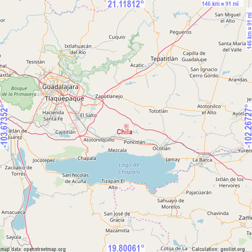
Chila GPS coordinates[2]
20° 27' 38.808" North, 102° 58' 13.404" West
| Map corner | latitude | longitude |
|---|---|---|
| Upper-left | 21.11812°, | -103.67352° |
| Center: | 20.46078°, | -102.97039° |
| Lower-right: | 19.80061°, | -102.26727° |
| Map W x H: | 146.5×146.5 km | = 91×91mi |
| max Lat: | 32.7° ⇑33.1% North |
| Chila: | 20.46078° |
| min Lat: | ⇓66.9% South 14.53588° |
| min Long | Chila | max Long |
| -117.105° | -102.97039° | -86.73105° |
| W 14.4%⇐ | ⇒85.6% E |
Elevation
Elevation of Chila is 1558 m = 5112 ft, and this is 304.3 m = 998 ft above average elevation for this country.
| Max E: |
3497 m = 11473 ft | 46.2% |
| Chila | 1558 m 5112 ft | |
| Avg. | 1253.7 m = 4113 ft | |
Min E: |
-1 m = -3 ft | 53.8% |
See also: Mexico elevation on elevation.city.
Geographical zone
Chila is located in North Torrid zone (between Equator and Tropic of Cancer). Distance of this Northern Tropic circle is 330.9 km =205.6 mi to North.| Distance of | km | miles | from Chila |
|---|---|---|---|
| North Pole | 7732 | 4804.4 | to North |
| Arctic Circle | 5126.1 | 3185.2 | to North |
| Tropic Cancer | 330.9 | 205.6 | to North |
| Equator | 2275 | 1413.6 | to South |


Nearby cities:
15 places around Chila: (largest is in red/bold)
• Agua Escondida
13.2 km =8.2 mi,  295°
295°
• Ahuatlán
9.8 km =6.1 mi,  118°
118°
• Cerro Santa Fe
13.9 km =8.6 mi, 301°
• El Romereño (INFONAVIT)
9.2 km =5.7 mi,  166°
166°
• La Colonia
5.6 km =3.5 mi,  132°
132°
• La Noria
12.9 km =8 mi,  92°
92°
• La Paz
12.3 km =7.6 mi,  316°
316°
• Mezcala
14.8 km =9.2 mi,  199°
199°
• Poncitlán
10.2 km =6.3 mi,  152°
152°
• San Jacinto
11.4 km =7.1 mi,  232°
232°
• San Miguel Zapotitlán
8.2 km =5.1 mi, 197°
• San Pedro Itzicán
16.1 km =10 mi, 173°
• Santa Cruz el Grande
14.6 km =9.1 mi, 130°
• Tecualtitán
7.2 km =4.5 mi,  236°
236°
• Zapotlán del Rey
4.7 km =2.9 mi,  82°
82°
Sources, notices
• [Note1] Compared only with cities in Mexico existing in our database
• [Src1] Map data: © OpenStreetMap contributors (CC-BY-SA)
• [Src2] Other city data from geonames.org with taken over terms of usage.
• [Src3] Geographical zone / Annual Mean Temperature by Robert A. Rohde @ Wikipedia
