Mazatán geodata
Mazatán (Sonora) is a seat of a second-order administrative division; located in Mexico in America/Hermosillo (GMT-7) time zone. With population of 1,285 people, there are 6745 cities with bigger population in this country. Compared to other cities in Mexico, 98% of cities are located further ↓South; 98.2% of cities are located further →East and 67.6% of cities have higher elevation than Mazatán. Note1


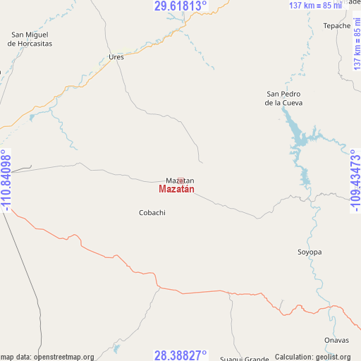
Mazatán GPS coordinates[2]
29° 0' 18.108" North, 110° 8' 16.26" West
| Map corner | latitude | longitude |
|---|---|---|
| Upper-left | 29.61813°, | -110.84098° |
| Center: | 29.00503°, | -110.13785° |
| Lower-right: | 28.38827°, | -109.43473° |
| Map W x H: | 136.7×136.7 km | = 84.9×84.9mi |
| max Lat: | 32.7° ⇑2% North |
| Mazatán: | 29.00503° |
| min Lat: | ⇓98% South 14.53588° |
| min Long | Mazatán | max Long |
| -117.105° | -110.13785° | -86.73105° |
| W 1.8%⇐ | ⇒98.2% E |
Elevation
Elevation of Mazatán is 547 m = 1795 ft, and this is 706.7 m = 2319 ft below average elevation for this country.
| Max E: |
3497 m = 11473 ft | 67.6% |
| Avg. | 1253.7 m = 4113 ft | |
| Mazatán | 547 m = 1795 ft | |
Min E: |
-1 m = -3 ft | 32.4% |
See also: Mexico elevation on elevation.city.
Geographical zone
Mazatán is located in North temperate zone (between Tropic of Cancer and the Arctic Circle). Distance of this Northern Tropic circle is 619.1 km =384.7 mi to South.| Distance of | km | miles | from Mazatán |
|---|---|---|---|
| North Pole | 6782 | 4214.1 | to North |
| Arctic Circle | 4176.1 | 2594.9 | to North |
| Tropic Cancer | 619.1 | 384.7 | to South |
| Equator | 3225.1 | 2004 | to South |


Nearby cities:
15 places around Mazatán: (largest is in red/bold)
• Bacanora
71.8 km =44.6 mi,  92°
92°
• El Alamito Buenavista
72.1 km =44.8 mi,  285°
285°
• Estación Zamora
78.1 km =48.5 mi, 291°
• Guadalupe
51.9 km =32.2 mi,  324°
324°
• La Colorada
48.5 km =30.1 mi,  242°
242°
• La Victoria
74.3 km =46.2 mi,  280°
280°
• Molino de Camou
64.2 km =39.9 mi, 290°
• Pueblo de Álamos
22.4 km =13.9 mi,  359°
359°
• San Javier
59.8 km =37.2 mi,  139°
139°
• San Pedro de la Cueva
50 km =31.1 mi,  51°
51°
• Soyopa
55.8 km =34.7 mi,  118°
118°
• Suaqui Grande
72.2 km =44.9 mi,  160°
160°
• Tecoripa
46 km =28.6 mi, 157°
• Ures
52.8 km =32.8 mi,  332°
332°
• Villa Pesqueira
20.8 km =12.9 mi, 52°
Sources, notices
• [Note1] Compared only with cities in Mexico existing in our database
• [Src1] Map data: © OpenStreetMap contributors (CC-BY-SA)
• [Src2] Other city data from geonames.org with taken over terms of usage.
• [Src3] Geographical zone / Annual Mean Temperature by Robert A. Rohde @ Wikipedia
