Soyopa geodata
Soyopa (Sonora) is a seat of a second-order administrative division; located in Mexico in America/Hermosillo (GMT-7) time zone. With population of 130 people, there are 16894 cities with bigger population in this country. Compared to other cities in Mexico, 97.9% of cities are located further ↓South; 97.7% of cities are located further →East and 74.8% of cities have higher elevation than Soyopa. Note1


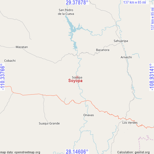
Soyopa GPS coordinates[2]
28° 45' 51.264" North, 109° 38' 4.308" West
| Map corner | latitude | longitude |
|---|---|---|
| Upper-left | 29.37878°, | -110.33766° |
| Center: | 28.76424°, | -109.63453° |
| Lower-right: | 28.14606°, | -108.93141° |
| Map W x H: | 137.1×137.1 km | = 85.2×85.2mi |
| max Lat: | 32.7° ⇑2.1% North |
| Soyopa: | 28.76424° |
| min Lat: | ⇓97.9% South 14.53588° |
| min Long | Soyopa | max Long |
| -117.105° | -109.63453° | -86.73105° |
| W 2.3%⇐ | ⇒97.7% E |
Elevation
Elevation of Soyopa is 229 m = 751 ft, and this is 1024.7 m = 3362 ft below average elevation for this country.
| Max E: |
3497 m = 11473 ft | 74.8% |
| Avg. | 1253.7 m = 4113 ft | |
| Soyopa | 229 m = 751 ft | |
Min E: |
-1 m = -3 ft | 25.2% |
See also: Mexico elevation on elevation.city.
Geographical zone
Soyopa is located in North temperate zone (between Tropic of Cancer and the Arctic Circle). Distance of this Northern Tropic circle is 592.4 km =368.1 mi to South.| Distance of | km | miles | from Soyopa |
|---|---|---|---|
| North Pole | 6808.8 | 4230.8 | to North |
| Arctic Circle | 4202.9 | 2611.6 | to North |
| Tropic Cancer | 592.4 | 368.1 | to South |
| Equator | 3198.3 | 1987.3 | to South |


Nearby cities:
15 places around Soyopa: (largest is in red/bold)
• Arivechi
47.2 km =29.3 mi,  67°
67°
• Bacanora
33.2 km =20.6 mi,  43°
43°
• Divisaderos
95.9 km =59.6 mi,  9°
9°
• La Colorada
92.2 km =57.3 mi,  272°
272°
• Mazatán
55.8 km =34.7 mi,  298°
298°
• Onavas
35.2 km =21.9 mi,  163°
163°
• Pueblo de Álamos
69.6 km =43.2 mi,  314°
314°
• Sahuaripa
50.6 km =31.4 mi,  50°
50°
• San Javier
21.4 km =13.3 mi,  208°
208°
• San Pedro de la Cueva
59 km =36.7 mi,  350°
350°
• Suaqui Grande
48 km =29.8 mi, 211°
• Tecoripa
34.9 km =21.7 mi,  243°
243°
• Tepache
86 km =53.4 mi, 6°
• Villa Pesqueira
51 km =31.7 mi,  320°
320°
• Yécora
81.7 km =50.8 mi,  122°
122°
Sources, notices
• [Note1] Compared only with cities in Mexico existing in our database
• [Src1] Map data: © OpenStreetMap contributors (CC-BY-SA)
• [Src2] Other city data from geonames.org with taken over terms of usage.
• [Src3] Geographical zone / Annual Mean Temperature by Robert A. Rohde @ Wikipedia
