Ures geodata
Ures (Sonora) is a seat of a second-order administrative division; located in Mexico in America/Hermosillo (GMT-7) time zone. With population of 3,894 people, there are 2349 cities with bigger population in this country. Compared to other cities in Mexico, 98.3% of cities are located further ↓South; 98.4% of cities are located further →East and 70.6% of cities have higher elevation than Ures. Note1


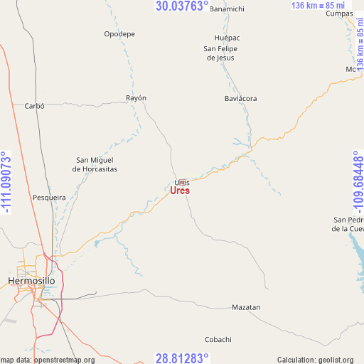
Ures GPS coordinates[2]
29° 25' 37.488" North, 110° 23' 15.36" West
| Map corner | latitude | longitude |
|---|---|---|
| Upper-left | 30.03763°, | -111.09073° |
| Center: | 29.42708°, | -110.3876° |
| Lower-right: | 28.81283°, | -109.68448° |
| Map W x H: | 136.2×136.2 km | = 84.6×84.6mi |
| max Lat: | 32.7° ⇑1.7% North |
| Ures: | 29.42708° |
| min Lat: | ⇓98.3% South 14.53588° |
| min Long | Ures | max Long |
| -117.105° | -110.3876° | -86.73105° |
| W 1.6%⇐ | ⇒98.4% E |
Elevation
Elevation of Ures is 387 m = 1270 ft, and this is 866.7 m = 2844 ft below average elevation for this country.
| Max E: |
3497 m = 11473 ft | 70.6% |
| Avg. | 1253.7 m = 4113 ft | |
| Ures | 387 m = 1270 ft | |
Min E: |
-1 m = -3 ft | 29.4% |
See also: Mexico elevation on elevation.city.
Geographical zone
Ures is located in North temperate zone (between Tropic of Cancer and the Arctic Circle). Distance of this Northern Tropic circle is 666.1 km =413.9 mi to South.| Distance of | km | miles | from Ures |
|---|---|---|---|
| North Pole | 6735.1 | 4185 | to North |
| Arctic Circle | 4129.2 | 2565.8 | to North |
| Tropic Cancer | 666.1 | 413.9 | to South |
| Equator | 3272 | 2033.1 | to South |


Nearby cities:
15 places around Ures: (largest is in red/bold)
• Aconchi
47.1 km =29.3 mi,  19°
19°
• Baviácora
38.5 km =23.9 mi,  34°
34°
• El Alamito Buenavista
52.9 km =32.9 mi,  238°
238°
• Estación Zamora
51.8 km =32.2 mi,  249°
249°
• Guadalupe
7.7 km =4.8 mi,  231°
231°
• La Estancia
44.3 km =27.5 mi, 22°
• Las Mercedes [Agropecuaria]
55.1 km =34.2 mi,  262°
262°
• Mazatán
52.8 km =32.8 mi,  152°
152°
• Molino de Camou
43.6 km =27.1 mi, 235°
• Pesqueira
49.5 km =30.8 mi, 263°
• Pueblo de Álamos
34.3 km =21.3 mi,  135°
135°
• Rayón
36.1 km =22.4 mi,  331°
331°
• San Felipe de Jesús
50.4 km =31.3 mi, 16°
• San Miguel de Horcasitas
33.3 km =20.7 mi,  281°
281°
• Villa Pesqueira
53.3 km =33.1 mi,  130°
130°
Sources, notices
• [Note1] Compared only with cities in Mexico existing in our database
• [Src1] Map data: © OpenStreetMap contributors (CC-BY-SA)
• [Src2] Other city data from geonames.org with taken over terms of usage.
• [Src3] Geographical zone / Annual Mean Temperature by Robert A. Rohde @ Wikipedia
