Tecoripa geodata
Tecoripa (Sonora) is a populated place; located in Mexico in America/Hermosillo (GMT-7) time zone. With population of 525 people, there are 16085 cities with bigger population in this country. Compared to other cities in Mexico, 97.9% of cities are located further ↓South; 98.1% of cities are located further →East and 70.3% of cities have higher elevation than Tecoripa. Note1


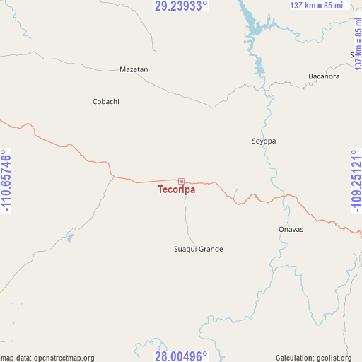
Tecoripa GPS coordinates[2]
28° 37' 26.256" North, 109° 57' 15.588" West
| Map corner | latitude | longitude |
|---|---|---|
| Upper-left | 29.23933°, | -110.65746° |
| Center: | 28.62396°, | -109.95433° |
| Lower-right: | 28.00496°, | -109.25121° |
| Map W x H: | 137.2×137.2 km | = 85.3×85.3mi |
| max Lat: | 32.7° ⇑2.1% North |
| Tecoripa: | 28.62396° |
| min Lat: | ⇓97.9% South 14.53588° |
| min Long | Tecoripa | max Long |
| -117.105° | -109.95433° | -86.73105° |
| W 1.9%⇐ | ⇒98.1% E |
Elevation
Elevation of Tecoripa is 401 m = 1316 ft, and this is 852.7 m = 2798 ft below average elevation for this country.
| Max E: |
3497 m = 11473 ft | 70.3% |
| Avg. | 1253.7 m = 4113 ft | |
| Tecoripa | 401 m = 1316 ft | |
Min E: |
-1 m = -3 ft | 29.7% |
See also: Mexico elevation on elevation.city.
Geographical zone
Tecoripa is located in North temperate zone (between Tropic of Cancer and the Arctic Circle). Distance of this Northern Tropic circle is 576.8 km =358.4 mi to South.| Distance of | km | miles | from Tecoripa |
|---|---|---|---|
| North Pole | 6824.4 | 4240.5 | to North |
| Arctic Circle | 4218.5 | 2621.3 | to North |
| Tropic Cancer | 576.8 | 358.4 | to South |
| Equator | 3182.7 | 1977.6 | to South |


Nearby cities:
15 places around Tecoripa: (largest is in red/bold)
• Antonio Rosales
88.5 km =55 mi,  226°
226°
• Arivechi
82.1 km =51 mi,  65°
65°
• Bacanora
67.1 km =41.7 mi,  53°
53°
• Francisco Márquez
81 km =50.3 mi, 230°
• La Colorada
64.2 km =39.9 mi,  288°
288°
• Mazatán
46 km =28.6 mi,  337°
337°
• Onavas
45.2 km =28.1 mi,  113°
113°
• Ortiz
83.1 km =51.6 mi,  243°
243°
• Pueblo de Álamos
67.2 km =41.8 mi, 344°
• Sahuaripa
84.9 km =52.8 mi,  55°
55°
• San Javier
21.2 km =13.2 mi,  98°
98°
• San Pedro de la Cueva
76.7 km =47.7 mi,  16°
16°
• Soyopa
34.9 km =21.7 mi, 63°
• Suaqui Grande
26.4 km =16.4 mi,  165°
165°
• Villa Pesqueira
55 km =34.2 mi,  358°
358°
Sources, notices
• [Note1] Compared only with cities in Mexico existing in our database
• [Src1] Map data: © OpenStreetMap contributors (CC-BY-SA)
• [Src2] Other city data from geonames.org with taken over terms of usage.
• [Src3] Geographical zone / Annual Mean Temperature by Robert A. Rohde @ Wikipedia
