Pueblo Nuevo geodata
Pueblo Nuevo (Nayarit) is a populated place; located in Mexico in America/Mazatlan (GMT-7) time zone. With population of 509 people, there are 16517 cities with bigger population in this country. Compared to other cities in Mexico, 82.8% of cities are located further ↓South; 92.7% of cities are located further →East and 97% of cities have higher elevation than Pueblo Nuevo. Note1


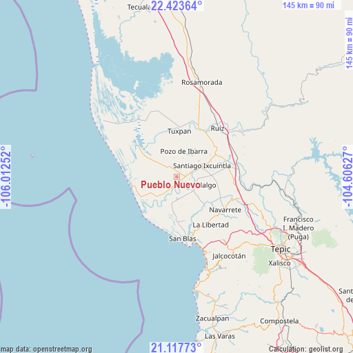
Pueblo Nuevo GPS coordinates[2]
21° 46' 19.812" North, 105° 18' 33.804" West
| Map corner | latitude | longitude |
|---|---|---|
| Upper-left | 22.42364°, | -106.01252° |
| Center: | 21.77217°, | -105.30939° |
| Lower-right: | 21.11773°, | -104.60627° |
| Map W x H: | 145.2×145.2 km | = 90.2×90.2mi |
| max Lat: | 32.7° ⇑17.2% North |
| Pueblo Nuevo: | 21.77217° |
| min Lat: | ⇓82.8% South 14.53588° |
| min Long | Pueblo Nuevo | max Long |
| -117.105° | -105.30939° | -86.73105° |
| W 7.3%⇐ | ⇒92.7% E |
Elevation
Elevation of Pueblo Nuevo is 10 m = 33 ft, and this is 1243.7 m = 4080 ft below average elevation for this country.
| Max E: |
3497 m = 11473 ft | 97% |
| Avg. | 1253.7 m = 4113 ft | |
| Pueblo Nuevo | 10 m = 33 ft | |
Min E: |
-1 m = -3 ft | 3% |
See also: Mexico elevation on elevation.city.
Geographical zone
Pueblo Nuevo is located in North Torrid zone (between Equator and Tropic of Cancer). Distance of this Northern Tropic circle is 185.1 km =115 mi to North.| Distance of | km | miles | from Pueblo Nuevo |
|---|---|---|---|
| North Pole | 7586.2 | 4713.8 | to North |
| Arctic Circle | 4980.3 | 3094.6 | to North |
| Tropic Cancer | 185.1 | 115 | to North |
| Equator | 2420.8 | 1504.2 | to South |


Nearby cities:
15 places around Pueblo Nuevo: (largest is in red/bold)
• Amapa
5.8 km =3.6 mi,  77°
77°
• Aután
9.2 km =5.7 mi,  178°
178°
• Cañada del Tabaco
8.3 km =5.2 mi,  213°
213°
• Cerritos
4 km =2.5 mi, 75°
• El Botadero
3.1 km =1.9 mi,  130°
130°
• El Corte
8.8 km =5.5 mi, 130°
• El Limón
7.9 km =4.9 mi,  351°
351°
• El Madrigaleño
10 km =6.2 mi,  192°
192°
• Gavilán Grande
3.4 km =2.1 mi,  29°
29°
• La Goma
7.1 km =4.4 mi,  150°
150°
• Pozo de Villa
6.7 km =4.2 mi,  4°
4°
• Puerta de Mangos
6.5 km =4 mi,  204°
204°
• Sentispac
5.2 km =3.2 mi,  313°
313°
• Valle Morelos
8.2 km =5.1 mi,  19°
19°
• Villa Hidalgo
8.8 km =5.5 mi,  112°
112°
Sources, notices
• [Note1] Compared only with cities in Mexico existing in our database
• [Src1] Map data: © OpenStreetMap contributors (CC-BY-SA)
• [Src2] Other city data from geonames.org with taken over terms of usage.
• [Src3] Geographical zone / Annual Mean Temperature by Robert A. Rohde @ Wikipedia
