Villa Hidalgo geodata
Villa Hidalgo (Nayarit) is a populated place; located in Mexico in America/Mazatlan (GMT-7) time zone. With population of 9,908 people, there are 963 cities with bigger population in this country. Compared to other cities in Mexico, 82.7% of cities are located further ↓South; 92.5% of cities are located further →East and 95.1% of cities have higher elevation than Villa Hidalgo. Note1


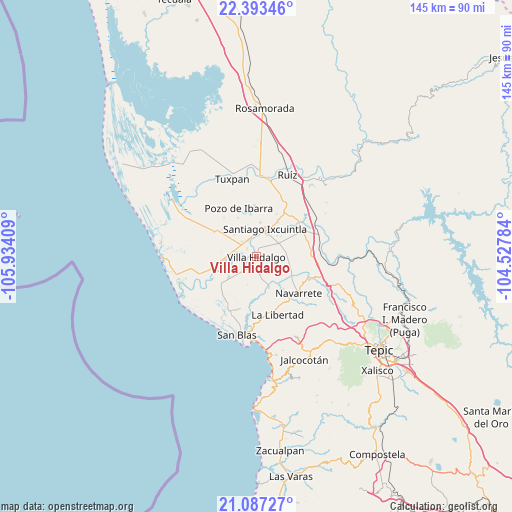
Villa Hidalgo GPS coordinates[2]
21° 44' 30.66" North, 105° 13' 51.456" West
| Map corner | latitude | longitude |
|---|---|---|
| Upper-left | 22.39346°, | -105.93409° |
| Center: | 21.74185°, | -105.23096° |
| Lower-right: | 21.08727°, | -104.52784° |
| Map W x H: | 145.2×145.2 km | = 90.2×90.2mi |
| max Lat: | 32.7° ⇑17.3% North |
| Villa Hidalgo: | 21.74185° |
| min Lat: | ⇓82.7% South 14.53588° |
| min Long | Villa Hidalgo | max Long |
| -117.105° | -105.23096° | -86.73105° |
| W 7.5%⇐ | ⇒92.5% E |
Elevation
Elevation of Villa Hidalgo is 13 m = 43 ft, and this is 1240.7 m = 4071 ft below average elevation for this country.
| Max E: |
3497 m = 11473 ft | 95.1% |
| Avg. | 1253.7 m = 4113 ft | |
| Villa Hidalgo | 13 m = 43 ft | |
Min E: |
-1 m = -3 ft | 4.9% |
See also: Mexico elevation on elevation.city.
Geographical zone
Villa Hidalgo is located in North Torrid zone (between Equator and Tropic of Cancer). Distance of this Northern Tropic circle is 188.5 km =117.1 mi to North.| Distance of | km | miles | from Villa Hidalgo |
|---|---|---|---|
| North Pole | 7589.6 | 4716 | to North |
| Arctic Circle | 4983.7 | 3096.7 | to North |
| Tropic Cancer | 188.5 | 117.1 | to North |
| Equator | 2417.5 | 1502.2 | to South |


Nearby cities:
15 places around Villa Hidalgo: (largest is in red/bold)
• Amapa
5.3 km =3.3 mi,  332°
332°
• Aután
9.8 km =6.1 mi,  233°
233°
• Cerritos
6.1 km =3.8 mi,  316°
316°
• Colonia Emiliano Zapata
9.7 km =6 mi,  6°
6°
• El Botadero
5.9 km =3.7 mi,  283°
283°
• El Corte
2.8 km =1.7 mi,  210°
210°
• Gavilán Grande
9 km =5.6 mi,  314°
314°
• La Goma
5.4 km =3.4 mi,  238°
238°
• La Presa
7.2 km =4.5 mi,  25°
25°
• Leandro B. Flores
7.1 km =4.4 mi,  58°
58°
• Pueblo Nuevo
8.8 km =5.5 mi,  292°
292°
• Puerta de Mangos
11.1 km =6.9 mi,  256°
256°
• Reforma Agraria
9.5 km =5.9 mi,  158°
158°
• Santiago Ixcuintla
8.2 km =5.1 mi,  16°
16°
• Sauta
9.4 km =5.8 mi,  104°
104°
Sources, notices
• [Note1] Compared only with cities in Mexico existing in our database
• [Src1] Map data: © OpenStreetMap contributors (CC-BY-SA)
• [Src2] Other city data from geonames.org with taken over terms of usage.
• [Src3] Geographical zone / Annual Mean Temperature by Robert A. Rohde @ Wikipedia
