Los Mezquites geodata
Los Mezquites (Nayarit) is a populated place; located in Mexico in America/Mazatlan (GMT-7) time zone. With population of 603 people, there are 14266 cities with bigger population in this country. Compared to other cities in Mexico, 75.1% of cities are located further ↓South; 91.1% of cities are located further →East and 67.7% of cities have higher elevation than Los Mezquites. Note1


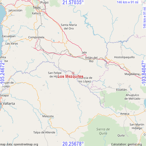
Los Mezquites GPS coordinates[2]
20° 54' 54" North, 104° 32' 36.924" West
| Map corner | latitude | longitude |
|---|---|---|
| Upper-left | 21.57035°, | -105.24672° |
| Center: | 20.915°, | -104.54359° |
| Lower-right: | 20.25678°, | -103.84047° |
| Map W x H: | 146.1×146.1 km | = 90.8×90.8mi |
| max Lat: | 32.7° ⇑24.9% North |
| Los Mezquites: | 20.915° |
| min Lat: | ⇓75.1% South 14.53588° |
| min Long | Los Mezquites | max Long |
| -117.105° | -104.54359° | -86.73105° |
| W 8.9%⇐ | ⇒91.1% E |
Elevation
Elevation of Los Mezquites is 541 m = 1775 ft, and this is 712.7 m = 2338 ft below average elevation for this country.
| Max E: |
3497 m = 11473 ft | 67.7% |
| Avg. | 1253.7 m = 4113 ft | |
| Los Mezquites | 541 m = 1775 ft | |
Min E: |
-1 m = -3 ft | 32.3% |
See also: Mexico elevation on elevation.city.
Geographical zone
Los Mezquites is located in North Torrid zone (between Equator and Tropic of Cancer). Distance of this Northern Tropic circle is 280.4 km =174.2 mi to North.| Distance of | km | miles | from Los Mezquites |
|---|---|---|---|
| North Pole | 7681.5 | 4773.1 | to North |
| Arctic Circle | 5075.6 | 3153.8 | to North |
| Tropic Cancer | 280.4 | 174.2 | to North |
| Equator | 2325.5 | 1445 | to South |


Nearby cities:
15 places around Los Mezquites: (largest is in red/bold)
• Ahuacatlán
16.7 km =10.4 mi,  21°
21°
• Amatlán de Cañas
18.8 km =11.7 mi,  129°
129°
• El Rosario
8.2 km =5.1 mi,  108°
108°
• Heriberto Jara
15.5 km =9.6 mi,  9°
9°
• Ixtlán del Río
22.6 km =14 mi,  52°
52°
• Jala
23.8 km =14.8 mi,  27°
27°
• Jomulco
24.4 km =15.2 mi, 30°
• Marquezado
18.2 km =11.3 mi,  350°
350°
• Méxpan
18.9 km =11.7 mi,  44°
44°
• San Felipe de Híjar
18.6 km =11.6 mi,  265°
265°
• Santa Cruz de Camotlán
13.9 km =8.6 mi,  289°
289°
• Tepuzhuacán
4.9 km =3 mi,  149°
149°
• Tetitlán
25 km =15.5 mi,  342°
342°
• Uzeta
23 km =14.3 mi, 344°
• Valle Verde
24.2 km =15 mi, 340°
Sources, notices
• [Note1] Compared only with cities in Mexico existing in our database
• [Src1] Map data: © OpenStreetMap contributors (CC-BY-SA)
• [Src2] Other city data from geonames.org with taken over terms of usage.
• [Src3] Geographical zone / Annual Mean Temperature by Robert A. Rohde @ Wikipedia
