Amatlán de Cañas geodata
Amatlán de Cañas (Nayarit) is a seat of a second-order administrative division; located in Mexico in America/Mazatlan (GMT-7) time zone. With population of 3,157 people, there are 2862 cities with bigger population in this country. Compared to other cities in Mexico, 73.4% of cities are located further ↓South; 90.8% of cities are located further →East and 64.1% of cities have higher elevation than Amatlán de Cañas. Note1


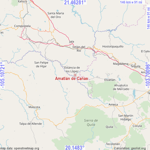
Amatlán de Cañas GPS coordinates[2]
20° 48' 25.164" North, 104° 24' 14.688" West
| Map corner | latitude | longitude |
|---|---|---|
| Upper-left | 21.46281°, | -105.10721° |
| Center: | 20.80699°, | -104.40408° |
| Lower-right: | 20.1483°, | -103.70096° |
| Map W x H: | 146.2×146.2 km | = 90.8×90.8mi |
| max Lat: | 32.7° ⇑26.6% North |
| Amatlán de Cañas: | 20.80699° |
| min Lat: | ⇓73.4% South 14.53588° |
| min Long | Amatlán de Ca� | max Long |
| -117.105° | -104.40408° | -86.73105° |
| W 9.2%⇐ | ⇒90.8% E |
Elevation
Elevation of Amatlán de Cañas is 748 m = 2454 ft, and this is 505.7 m = 1659 ft below average elevation for this country.
| Max E: |
3497 m = 11473 ft | 64.1% |
| Avg. | 1253.7 m = 4113 ft | |
| Amatlán de Cañas | 748 m = 2454 ft | |
Min E: |
-1 m = -3 ft | 35.9% |
See also: Mexico elevation on elevation.city.
Geographical zone
Amatlán de Cañas is located in North Torrid zone (between Equator and Tropic of Cancer). Distance of this Northern Tropic circle is 292.4 km =181.7 mi to North.| Distance of | km | miles | from Amatlán de Cañas |
|---|---|---|---|
| North Pole | 7693.5 | 4780.5 | to North |
| Arctic Circle | 5087.7 | 3161.3 | to North |
| Tropic Cancer | 292.4 | 181.7 | to North |
| Equator | 2313.5 | 1437.5 | to South |


Nearby cities:
15 places around Amatlán de Cañas: (largest is in red/bold)
• Ahuacatlán
28.7 km =17.8 mi,  343°
343°
• El Rosario
11.6 km =7.2 mi,  324°
324°
• Francisco I. Madero (La Bolsa)
32.8 km =20.4 mi,  14°
14°
• Guachinango
25.7 km =16 mi,  174°
174°
• Heriberto Jara
29.7 km =18.5 mi, 336°
• Ixtlán del Río
26 km =16.2 mi, 7°
• Jomulco
33.1 km =20.6 mi,  356°
356°
• La Laja
27.6 km =17.1 mi,  207°
207°
• Los Mezquites
18.8 km =11.7 mi,  309°
309°
• Méxpan
25.5 km =15.8 mi, 357°
• Oconahua
25.9 km =16.1 mi,  106°
106°
• San Marcos
21.6 km =13.4 mi,  94°
94°
• Santa Cruz de Camotlán
32.3 km =20.1 mi,  301°
301°
• Santa Rosalía
33.1 km =20.6 mi, 88°
• Tepuzhuacán
14.3 km =8.9 mi, 302°
Sources, notices
• [Note1] Compared only with cities in Mexico existing in our database
• [Src1] Map data: © OpenStreetMap contributors (CC-BY-SA)
• [Src2] Other city data from geonames.org with taken over terms of usage.
• [Src3] Geographical zone / Annual Mean Temperature by Robert A. Rohde @ Wikipedia
