La Ventana geodata
La Ventana (San Luis Potosí) is a populated place; located in Mexico in America/Mexico_City (GMT-6) time zone. With population of 758 people, there are 11551 cities with bigger population in this country. Compared to other cities in Mexico, 88% of cities are located further ↓South; 67% of cities are located further →East and 50.7% of cities have lower elevation than La Ventana. Note1


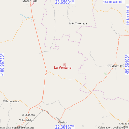
La Ventana GPS coordinates[2]
23° 0' 37.404" North, 100° 15' 51.12" West
| Map corner | latitude | longitude |
|---|---|---|
| Upper-left | 23.65601°, | -100.96733° |
| Center: | 23.01039°, | -100.2642° |
| Lower-right: | 22.36167°, | -99.56108° |
| Map W x H: | 143.9×143.9 km | = 89.4×89.4mi |
| max Lat: | 32.7° ⇑12% North |
| La Ventana: | 23.01039° |
| min Lat: | ⇓88% South 14.53588° |
| min Long | La Ventana | max Long |
| -117.105° | -100.2642° | -86.73105° |
| W 33%⇐ | ⇒67% E |
Elevation
Elevation of La Ventana is 1470 m = 4823 ft, and this is 216.3 m = 710 ft above average elevation for this country.
| Max E: |
3497 m = 11473 ft | 49.3% |
| La Ventana | 1470 m 4823 ft | |
| Avg. | 1253.7 m = 4113 ft | |
Min E: |
-1 m = -3 ft | 50.7% |
See also: Mexico elevation on elevation.city.
Geographical zone
La Ventana is located in North Torrid zone (between Equator and Tropic of Cancer). Distance of this Northern Tropic circle is 47.4 km =29.5 mi to North.| Distance of | km | miles | from La Ventana |
|---|---|---|---|
| North Pole | 7448.5 | 4628.3 | to North |
| Arctic Circle | 4842.7 | 3009.1 | to North |
| Tropic Cancer | 47.4 | 29.5 | to North |
| Equator | 2558.5 | 1589.8 | to South |


Nearby cities:
15 places around La Ventana: (largest is in red/bold)
• Cerros Blancos
37.2 km =23.1 mi,  11°
11°
• Coyote
34.1 km =21.2 mi,  248°
248°
• El Huisache
17.1 km =10.6 mi,  232°
232°
• Entronque de Matehuala (El Huizache)
22.1 km =13.7 mi,  244°
244°
• La Moreña
40 km =24.9 mi,  351°
351°
• La Pólvora
11.7 km =7.3 mi,  220°
220°
• Lázaro Cárdenas
22 km =13.7 mi,  101°
101°
• Negritas
26.4 km =16.4 mi,  156°
156°
• Norias del Refugio
21.3 km =13.2 mi,  270°
270°
• Pozas de Santa Ana
29.7 km =18.5 mi, 221°
• San Ignacio
21.9 km =13.6 mi,  23°
23°
• San Juan sin Agua
24.3 km =15.1 mi, 250°
• Santa Rosa La Masita
38.8 km =24.1 mi,  294°
294°
• Santa Teresa
28.7 km =17.8 mi, 270°
• Santo Domingo
16.2 km =10.1 mi,  186°
186°
Sources, notices
• [Note1] Compared only with cities in Mexico existing in our database
• [Src1] Map data: © OpenStreetMap contributors (CC-BY-SA)
• [Src2] Other city data from geonames.org with taken over terms of usage.
• [Src3] Geographical zone / Annual Mean Temperature by Robert A. Rohde @ Wikipedia
