Guarapo geodata
Guarapo (Guanajuato) is a populated place; located in Mexico in America/Mexico_City (GMT-6) time zone. With population of 725 people, there are 12042 cities with bigger population in this country. Compared to other cities in Mexico, 65.2% of cities are located further ↓South; 76.6% of cities are located further →East and 58.4% of cities have lower elevation than Guarapo. Note1


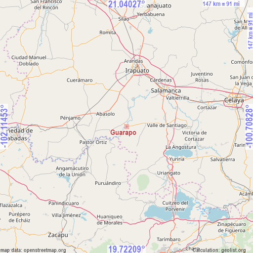
Guarapo GPS coordinates[2]
20° 22' 57.324" North, 101° 24' 41.04" West
| Map corner | latitude | longitude |
|---|---|---|
| Upper-left | 21.04027°, | -102.11453° |
| Center: | 20.38259°, | -101.4114° |
| Lower-right: | 19.72209°, | -100.70828° |
| Map W x H: | 146.6×146.6 km | = 91.1×91.1mi |
| max Lat: | 32.7° ⇑34.8% North |
| Guarapo: | 20.38259° |
| min Lat: | ⇓65.2% South 14.53588° |
| min Long | Guarapo | max Long |
| -117.105° | -101.4114° | -86.73105° |
| W 23.4%⇐ | ⇒76.6% E |
Elevation
Elevation of Guarapo is 1697 m = 5568 ft, and this is 443.3 m = 1454 ft above average elevation for this country.
| Max E: |
3497 m = 11473 ft | 41.6% |
| Guarapo | 1697 m 5568 ft | |
| Avg. | 1253.7 m = 4113 ft | |
Min E: |
-1 m = -3 ft | 58.4% |
See also: Mexico elevation on elevation.city.
Geographical zone
Guarapo is located in North Torrid zone (between Equator and Tropic of Cancer). Distance of this Northern Tropic circle is 339.6 km =211 mi to North.| Distance of | km | miles | from Guarapo |
|---|---|---|---|
| North Pole | 7740.7 | 4809.8 | to North |
| Arctic Circle | 5134.8 | 3190.6 | to North |
| Tropic Cancer | 339.6 | 211 | to North |
| Equator | 2266.3 | 1408.2 | to South |


Nearby cities:
15 places around Guarapo: (largest is in red/bold)
• Boquillas
4.4 km =2.7 mi,  328°
328°
• Cerro Colorado
9.3 km =5.8 mi,  77°
77°
• Charco de Pantoja
6 km =3.7 mi, 82°
• Cora
8.2 km =5.1 mi,  225°
225°
• Huanímaro
9.2 km =5.7 mi,  259°
259°
• Labor de Peralta
2.9 km =1.8 mi,  4°
4°
• Las Cañas
9.7 km =6 mi,  184°
184°
• Las Raíces
3.7 km =2.3 mi,  216°
216°
• Los Martínez
9.2 km =5.7 mi,  165°
165°
• Otates
7.6 km =4.7 mi,  285°
285°
• Piedras Negras
5.7 km =3.5 mi,  21°
21°
• Salitre de Aguilares
7.9 km =4.9 mi,  204°
204°
• San Cristóbal
1.7 km =1.1 mi,  57°
57°
• San José de Ayala
3.2 km =2 mi,  279°
279°
• Zapote de Peralta
7.8 km =4.8 mi,  12°
12°
Sources, notices
• [Note1] Compared only with cities in Mexico existing in our database
• [Src1] Map data: © OpenStreetMap contributors (CC-BY-SA)
• [Src2] Other city data from geonames.org with taken over terms of usage.
• [Src3] Geographical zone / Annual Mean Temperature by Robert A. Rohde @ Wikipedia
