Labor de Medina geodata
Labor de Medina (Jalisco) is a populated place; located in Mexico in America/Mexico_City (GMT-6) time zone. With population of 863 people, there are 10137 cities with bigger population in this country. Compared to other cities in Mexico, 67.2% of cities are located further ↓South; 89.8% of cities are located further →East and 53.2% of cities have higher elevation than Labor de Medina. Note1


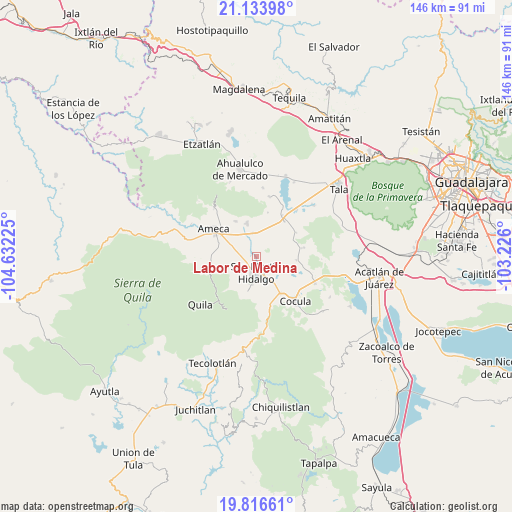
Labor de Medina GPS coordinates[2]
20° 28' 36.156" North, 103° 55' 44.832" West
| Map corner | latitude | longitude |
|---|---|---|
| Upper-left | 21.13398°, | -104.63225° |
| Center: | 20.47671°, | -103.92912° |
| Lower-right: | 19.81661°, | -103.226° |
| Map W x H: | 146.5×146.5 km | = 91×91mi |
| max Lat: | 32.7° ⇑32.8% North |
| Labor de Medina: | 20.47671° |
| min Lat: | ⇓67.2% South 14.53588° |
| min Long | Labor de Medina | max Long |
| -117.105° | -103.92912° | -86.73105° |
| W 10.2%⇐ | ⇒89.8% E |
Elevation
Elevation of Labor de Medina is 1280 m = 4199 ft, and this is 26.3 m = 86 ft above average elevation for this country.
| Max E: |
3497 m = 11473 ft | 53.2% |
| Labor de Medina | 1280 m 4199 ft | |
| Avg. | 1253.7 m = 4113 ft | |
Min E: |
-1 m = -3 ft | 46.8% |
See also: Mexico elevation on elevation.city.
Geographical zone
Labor de Medina is located in North Torrid zone (between Equator and Tropic of Cancer). Distance of this Northern Tropic circle is 329.1 km =204.5 mi to North.| Distance of | km | miles | from Labor de Medina |
|---|---|---|---|
| North Pole | 7730.3 | 4803.4 | to North |
| Arctic Circle | 5124.4 | 3184.2 | to North |
| Tropic Cancer | 329.1 | 204.5 | to North |
| Equator | 2276.8 | 1414.7 | to South |


Nearby cities:
15 places around Labor de Medina: (largest is in red/bold)
• Buenavista
13 km =8.1 mi,  38°
38°
• El Cabezón
3.1 km =1.9 mi,  312°
312°
• El Crucero de Santa María
12.6 km =7.8 mi,  145°
145°
• El Salitre
8.3 km =5.2 mi,  63°
63°
• Ipazoltic
7.6 km =4.7 mi,  232°
232°
• La Estanzuela
7.4 km =4.6 mi,  88°
88°
• La Sauceda
13 km =8.1 mi,  101°
101°
• Labor de Solís
11.8 km =7.3 mi,  329°
329°
• Los Guerrero
5 km =3.1 mi,  139°
139°
• Los Pocitos
6.8 km =4.2 mi,  352°
352°
• Punta de la Vega
13.1 km =8.1 mi,  14°
14°
• San Martín Hidalgo
4.6 km =2.9 mi,  179°
179°
• San Nicolás
11.5 km =7.1 mi, 94°
• Santa Cruz de las Flores
9.4 km =5.8 mi,  192°
192°
• Santa María
11.7 km =7.3 mi, 136°
Sources, notices
• [Note1] Compared only with cities in Mexico existing in our database
• [Src1] Map data: © OpenStreetMap contributors (CC-BY-SA)
• [Src2] Other city data from geonames.org with taken over terms of usage.
• [Src3] Geographical zone / Annual Mean Temperature by Robert A. Rohde @ Wikipedia
