La Pinta geodata
La Pinta (Coahuila) is a populated place; located in Mexico in America/Monterrey (GMT-6) time zone. With population of 1,165 people, there are 7447 cities with bigger population in this country. Compared to other cities in Mexico, 94.9% of cities are located further ↓South; 86.9% of cities are located further →East and 58% of cities have higher elevation than La Pinta. Note1


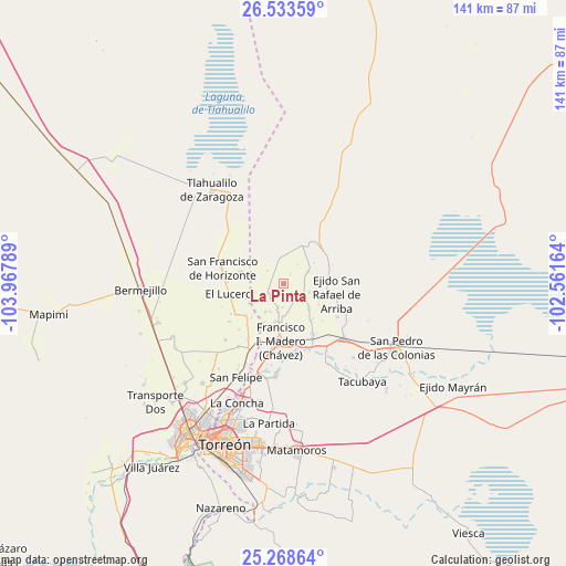
La Pinta GPS coordinates[2]
25° 54' 10.116" North, 103° 15' 53.136" West
| Map corner | latitude | longitude |
|---|---|---|
| Upper-left | 26.53359°, | -103.96789° |
| Center: | 25.90281°, | -103.26476° |
| Lower-right: | 25.26864°, | -102.56164° |
| Map W x H: | 140.6×140.7 km | = 87.4×87.4mi |
| max Lat: | 32.7° ⇑5.1% North |
| La Pinta: | 25.90281° |
| min Lat: | ⇓94.9% South 14.53588° |
| min Long | La Pinta | max Long |
| -117.105° | -103.26476° | -86.73105° |
| W 13.1%⇐ | ⇒86.9% E |
Elevation
Elevation of La Pinta is 1104 m = 3622 ft, and this is 149.7 m = 491 ft below average elevation for this country.
| Max E: |
3497 m = 11473 ft | 58% |
| Avg. | 1253.7 m = 4113 ft | |
| La Pinta | 1104 m = 3622 ft | |
Min E: |
-1 m = -3 ft | 42% |
See also: Mexico elevation on elevation.city.
Geographical zone
La Pinta is located in North temperate zone (between Tropic of Cancer and the Arctic Circle). Distance of this Northern Tropic circle is 274.2 km =170.4 mi to South.| Distance of | km | miles | from La Pinta |
|---|---|---|---|
| North Pole | 7126.9 | 4428.4 | to North |
| Arctic Circle | 4521.1 | 2809.3 | to North |
| Tropic Cancer | 274.2 | 170.4 | to South |
| Equator | 2880.1 | 1789.6 | to South |


Nearby cities:
15 places around La Pinta: (largest is in red/bold)
• Banco Nacional
9.8 km =6.1 mi,  249°
249°
• Colón
6 km =3.7 mi,  182°
182°
• Coruña
4.1 km =2.5 mi,  232°
232°
• Covadonga
3 km =1.9 mi,  35°
35°
• El Lequeitio
6.4 km =4 mi,  192°
192°
• Emiliano Zapata (Albia)
10.3 km =6.4 mi,  121°
121°
• Florencia
8.5 km =5.3 mi,  212°
212°
• Hidalgo
9.8 km =6.1 mi, 190°
• Huitrón
9.8 km =6.1 mi,  238°
238°
• La Fe
8.9 km =5.5 mi,  134°
134°
• La Victoria
9.8 km =6.1 mi, 115°
• Las Mercedes
7.8 km =4.8 mi,  204°
204°
• San José de la Niña
5.7 km =3.5 mi, 123°
• Santa María
4.4 km =2.7 mi,  151°
151°
• Vega Larga
6.8 km =4.2 mi,  108°
108°
Sources, notices
• [Note1] Compared only with cities in Mexico existing in our database
• [Src1] Map data: © OpenStreetMap contributors (CC-BY-SA)
• [Src2] Other city data from geonames.org with taken over terms of usage.
• [Src3] Geographical zone / Annual Mean Temperature by Robert A. Rohde @ Wikipedia
