Citala geodata
Citala (Jalisco) is a populated place; located in Mexico in America/Mexico_City (GMT-6) time zone. With population of 1,137 people, there are 7633 cities with bigger population in this country. Compared to other cities in Mexico, 59.3% of cities are located further ↓South; 86.9% of cities are located further →East and 50.4% of cities have higher elevation than Citala. Note1


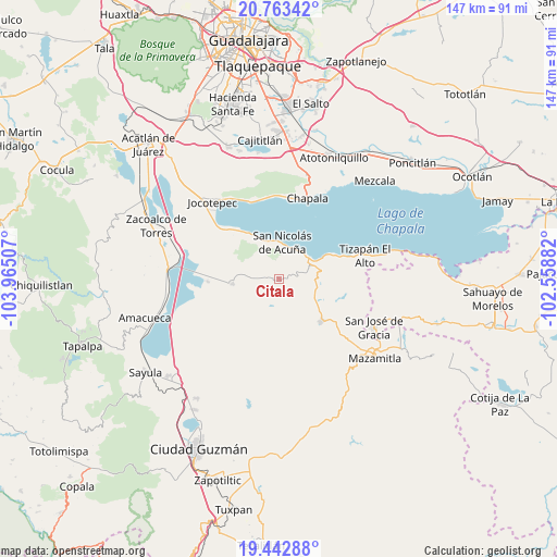
Citala GPS coordinates[2]
20° 6' 16.344" North, 103° 15' 42.984" West
| Map corner | latitude | longitude |
|---|---|---|
| Upper-left | 20.76342°, | -103.96507° |
| Center: | 20.10454°, | -103.26194° |
| Lower-right: | 19.44288°, | -102.55882° |
| Map W x H: | 146.8×146.8 km | = 91.2×91.2mi |
| max Lat: | 32.7° ⇑40.7% North |
| Citala: | 20.10454° |
| min Lat: | ⇓59.3% South 14.53588° |
| min Long | Citala | max Long |
| -117.105° | -103.26194° | -86.73105° |
| W 13.1%⇐ | ⇒86.9% E |
Elevation
Elevation of Citala is 1409 m = 4623 ft, and this is 155.3 m = 510 ft above average elevation for this country.
| Max E: |
3497 m = 11473 ft | 50.4% |
| Citala | 1409 m 4623 ft | |
| Avg. | 1253.7 m = 4113 ft | |
Min E: |
-1 m = -3 ft | 49.6% |
See also: Mexico elevation on elevation.city.
Geographical zone
Citala is located in North Torrid zone (between Equator and Tropic of Cancer). Distance of this Northern Tropic circle is 370.5 km =230.2 mi to North.| Distance of | km | miles | from Citala |
|---|---|---|---|
| North Pole | 7771.6 | 4829 | to North |
| Arctic Circle | 5165.8 | 3209.9 | to North |
| Tropic Cancer | 370.5 | 230.2 | to North |
| Equator | 2235.4 | 1389 | to South |


Nearby cities:
15 places around Citala: (largest is in red/bold)
• Ajijic
22.1 km =13.7 mi,  1°
1°
• Concepción de Buenos Aires
14 km =8.7 mi,  179°
179°
• El Volantín
17.2 km =10.7 mi,  108°
108°
• La Manzanilla de la Paz
15.8 km =9.8 mi,  134°
134°
• Milpilla
15.1 km =9.4 mi,  284°
284°
• Mismaloya
16.6 km =10.3 mi,  67°
67°
• San Cristóbal Zapotitlán
17.4 km =10.8 mi,  319°
319°
• San José de Gracia
18.7 km =11.6 mi,  267°
267°
• San Juan Cosalá
22 km =13.7 mi,  337°
337°
• San Luis Soyatlán
11.4 km =7.1 mi, 335°
• San Pedro Tesistán
21 km =13 mi,  310°
310°
• Teocuitatlán de Corona
12.2 km =7.6 mi,  263°
263°
• Tepeguaje
8.9 km =5.5 mi,  34°
34°
• Tuxcueca
9.7 km =6 mi,  55°
55°
• Villa Morelos
13.2 km =8.2 mi, 113°
Sources, notices
• [Note1] Compared only with cities in Mexico existing in our database
• [Src1] Map data: © OpenStreetMap contributors (CC-BY-SA)
• [Src2] Other city data from geonames.org with taken over terms of usage.
• [Src3] Geographical zone / Annual Mean Temperature by Robert A. Rohde @ Wikipedia
