Tepeguaje geodata
Tepeguaje (Jalisco) is a populated place; located in Mexico in America/Mexico_City (GMT-6) time zone. With population of 532 people, there are 15923 cities with bigger population in this country. Compared to other cities in Mexico, 60.7% of cities are located further ↓South; 86.6% of cities are located further →East and 52.4% of cities have lower elevation than Tepeguaje. Note1


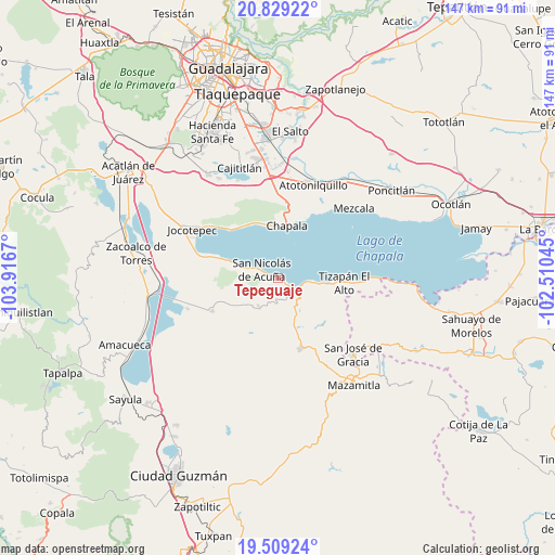
Tepeguaje GPS coordinates[2]
20° 10' 14.268" North, 103° 12' 48.852" West
| Map corner | latitude | longitude |
|---|---|---|
| Upper-left | 20.82922°, | -103.9167° |
| Center: | 20.17063°, | -103.21357° |
| Lower-right: | 19.50924°, | -102.51045° |
| Map W x H: | 146.8×146.8 km | = 91.2×91.2mi |
| max Lat: | 32.7° ⇑39.3% North |
| Tepeguaje: | 20.17063° |
| min Lat: | ⇓60.7% South 14.53588° |
| min Long | Tepeguaje | max Long |
| -117.105° | -103.21357° | -86.73105° |
| W 13.4%⇐ | ⇒86.6% E |
Elevation
Elevation of Tepeguaje is 1531 m = 5023 ft, and this is 277.3 m = 910 ft above average elevation for this country.
| Max E: |
3497 m = 11473 ft | 47.6% |
| Tepeguaje | 1531 m 5023 ft | |
| Avg. | 1253.7 m = 4113 ft | |
Min E: |
-1 m = -3 ft | 52.4% |
See also: Mexico elevation on elevation.city.
Geographical zone
Tepeguaje is located in North Torrid zone (between Equator and Tropic of Cancer). Distance of this Northern Tropic circle is 363.2 km =225.7 mi to North.| Distance of | km | miles | from Tepeguaje |
|---|---|---|---|
| North Pole | 7764.3 | 4824.5 | to North |
| Arctic Circle | 5158.4 | 3205.3 | to North |
| Tropic Cancer | 363.2 | 225.7 | to North |
| Equator | 2242.8 | 1393.6 | to South |


Nearby cities:
15 places around Tepeguaje: (largest is in red/bold)
• Ajijic
15.4 km =9.6 mi,  343°
343°
• Chapala
14.2 km =8.8 mi,  9°
9°
• Citala
8.9 km =5.5 mi,  214°
214°
• El Volantín
17.1 km =10.6 mi,  138°
138°
• La Manzanilla de la Paz
19.4 km =12.1 mi,  161°
161°
• Mismaloya
10.4 km =6.5 mi,  96°
96°
• San Cristóbal Zapotitlán
17.4 km =10.8 mi,  290°
290°
• San Juan Cosalá
18.6 km =11.6 mi,  314°
314°
• San Luis Soyatlán
10.2 km =6.3 mi, 287°
• San Nicolás de Ibarra
19.8 km =12.3 mi,  26°
26°
• Santa Cruz de la Soledad
17.3 km =10.7 mi,  19°
19°
• Teocuitatlán de Corona
19.3 km =12 mi,  243°
243°
• Tizapán el Alto
17.7 km =11 mi,  93°
93°
• Tuxcueca
3.5 km =2.2 mi,  121°
121°
• Villa Morelos
14.4 km =8.9 mi,  150°
150°
Sources, notices
• [Note1] Compared only with cities in Mexico existing in our database
• [Src1] Map data: © OpenStreetMap contributors (CC-BY-SA)
• [Src2] Other city data from geonames.org with taken over terms of usage.
• [Src3] Geographical zone / Annual Mean Temperature by Robert A. Rohde @ Wikipedia
