El Chanal geodata
El Chanal (Colima) is a populated place; located in Mexico in America/Mexico_City (GMT-6) time zone. With population of 820 people, there are 10646 cities with bigger population in this country. Compared to other cities in Mexico, 58.9% of cities are located further ↑North; 89.1% of cities are located further →East and 65.5% of cities have higher elevation than El Chanal. Note1


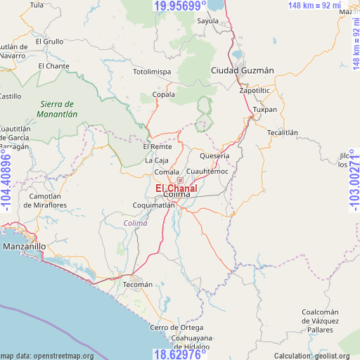
El Chanal GPS coordinates[2]
19° 17' 40.992" North, 103° 42' 20.988" West
| Map corner | latitude | longitude |
|---|---|---|
| Upper-left | 19.95699°, | -104.40896° |
| Center: | 19.29472°, | -103.70583° |
| Lower-right: | 18.62976°, | -103.00271° |
| Map W x H: | 147.6×147.6 km | = 91.7×91.7mi |
| max Lat: | 32.7° ⇑58.9% North |
| El Chanal: | 19.29472° |
| min Lat: | ⇓41.1% South 14.53588° |
| min Long | El Chanal | max Long |
| -117.105° | -103.70583° | -86.73105° |
| W 10.9%⇐ | ⇒89.1% E |
Elevation
Elevation of El Chanal is 659 m = 2162 ft, and this is 594.7 m = 1951 ft below average elevation for this country.
| Max E: |
3497 m = 11473 ft | 65.5% |
| Avg. | 1253.7 m = 4113 ft | |
| El Chanal | 659 m = 2162 ft | |
Min E: |
-1 m = -3 ft | 34.5% |
See also: Mexico elevation on elevation.city.
Geographical zone
El Chanal is located in North Torrid zone (between Equator and Tropic of Cancer). Distance of this Northern Tropic circle is 460.5 km =286.1 mi to North.| Distance of | km | miles | from El Chanal |
|---|---|---|---|
| North Pole | 7861.7 | 4885 | to North |
| Arctic Circle | 5255.8 | 3265.8 | to North |
| Tropic Cancer | 460.5 | 286.1 | to North |
| Equator | 2145.4 | 1333.1 | to South |


Nearby cities:
15 places around El Chanal: (largest is in red/bold)
• Alcaraces
15.6 km =9.7 mi,  60°
60°
• Buenavista
11.1 km =6.9 mi,  116°
116°
• Chiapa
7.2 km =4.5 mi,  49°
49°
• Ciudad de Villa de Álvarez
4.5 km =2.8 mi,  227°
227°
• Cofradía de Suchitlán
12.8 km =8 mi,  2°
2°
• Colima
5.5 km =3.4 mi,  204°
204°
• Comala
6.7 km =4.2 mi,  302°
302°
• Coquimatlán
14.7 km =9.1 mi, 227°
• Cuauhtémoc
11.4 km =7.1 mi,  70°
70°
• El Trapiche
5.1 km =3.2 mi,  111°
111°
• La Caja
12.9 km =8 mi,  310°
310°
• Ocotillo
7.3 km =4.5 mi, 53°
• Piscila
15.1 km =9.4 mi,  178°
178°
• Suchitlán
9 km =5.6 mi,  356°
356°
• Zacualpan
14.6 km =9.1 mi, 301°
Sources, notices
• [Note1] Compared only with cities in Mexico existing in our database
• [Src1] Map data: © OpenStreetMap contributors (CC-BY-SA)
• [Src2] Other city data from geonames.org with taken over terms of usage.
• [Src3] Geographical zone / Annual Mean Temperature by Robert A. Rohde @ Wikipedia
