Colima geodata
Colima is a seat of a first-order administrative division; located in Mexico in America/Mexico_City (GMT-6) time zone. With population of 137,383 people, there are 109 cities with bigger population in this country. Compared to other cities in Mexico, 59.9% of cities are located further ↑North; 89.2% of cities are located further →East and 68.4% of cities have higher elevation than Colima. Note1


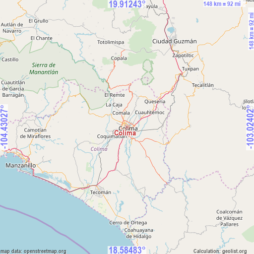
Colima GPS coordinates[2]
19° 14' 59.892" North, 103° 43' 37.704" West
| Map corner | latitude | longitude |
|---|---|---|
| Upper-left | 19.91243°, | -104.43027° |
| Center: | 19.24997°, | -103.72714° |
| Lower-right: | 18.58483°, | -103.02402° |
| Map W x H: | 147.6×147.6 km | = 91.7×91.7mi |
| max Lat: | 32.7° ⇑59.9% North |
| Colima: | 19.24997° |
| min Lat: | ⇓40.1% South 14.53588° |
| min Long | Colima | max Long |
| -117.105° | -103.72714° | -86.73105° |
| W 10.8%⇐ | ⇒89.2% E |
Elevation
Elevation of Colima is 502 m = 1647 ft, and this is 751.7 m = 2466 ft below average elevation for this country.
| Max E: |
3497 m = 11473 ft | 68.4% |
| Avg. | 1253.7 m = 4113 ft | |
| Colima | 502 m = 1647 ft | |
Min E: |
-1 m = -3 ft | 31.6% |
See also: Colima elevation on elevation.city.
Geographical zone
Colima is located in North Torrid zone (between Equator and Tropic of Cancer). Distance of this Northern Tropic circle is 465.5 km =289.2 mi to North.| Distance of | km | miles | from Colima |
|---|---|---|---|
| North Pole | 7866.7 | 4888.1 | to North |
| Arctic Circle | 5260.8 | 3268.9 | to North |
| Tropic Cancer | 465.5 | 289.2 | to North |
| Equator | 2140.4 | 1330 | to South |


Nearby cities:
15 places around Colima: (largest is in red/bold)
• Buenavista
12.2 km =7.6 mi,  89°
89°
• Chiapa
12.4 km =7.7 mi,  38°
38°
• Ciudad de Villa de Álvarez
2.2 km =1.4 mi,  329°
329°
• Comala
9.2 km =5.7 mi,  338°
338°
• Coquimatlán
9.9 km =6.2 mi,  240°
240°
• Cuauhtémoc
15.7 km =9.8 mi,  56°
56°
• El Chanal
5.5 km =3.4 mi,  24°
24°
• El Trapiche
7.6 km =4.7 mi,  65°
65°
• La Caja
15.4 km =9.6 mi, 330°
• Las Guásimas (Las Borregas)
14.9 km =9.3 mi,  179°
179°
• Los Asmoles
15.2 km =9.4 mi,  198°
198°
• Ocotillo
12.3 km =7.6 mi, 41°
• Piscila
10.5 km =6.5 mi,  164°
164°
• Suchitlán
14 km =8.7 mi,  6°
6°
• Zacualpan
16.2 km =10.1 mi,  320°
320°
Sources, notices
• [Note1] Compared only with cities in Mexico existing in our database
• [Src1] Map data: © OpenStreetMap contributors (CC-BY-SA)
• [Src2] Other city data from geonames.org with taken over terms of usage.
• [Src3] Geographical zone / Annual Mean Temperature by Robert A. Rohde @ Wikipedia
