Ciudad de Villa de Álvarez geodata
Ciudad de Villa de Álvarez (Colima) is a populated place; located in Mexico in America/Mexico_City (GMT-6) time zone. With population of 117,600 people, there are 123 cities with bigger population in this country. Compared to other cities in Mexico, 59.5% of cities are located further ↑North; 89.2% of cities are located further →East and 68% of cities have higher elevation than Ciudad de Villa de Álvarez. Note1
Current local time in Ciudad de Villa de Álvarez:
09:49 AM, TuesdayDifference from your time zone: hours


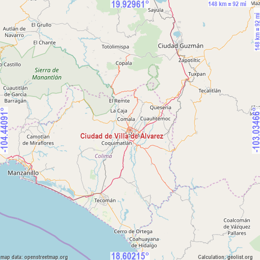
Ciudad de Villa de Álvarez GPS coordinates[2]
19° 16' 1.992" North, 103° 44' 16.008" West
| Map corner | latitude | longitude |
|---|---|---|
| Upper-left | 19.92961°, | -104.44091° |
| Center: | 19.26722°, | -103.73778° |
| Lower-right: | 18.60215°, | -103.03466° |
| Map W x H: | 147.6×147.6 km | = 91.7×91.7mi |
| max Lat: | 32.7° ⇑59.5% North |
| Ciudad de Villa de Álvarez: | 19.26722° |
| min Lat: | ⇓40.5% South 14.53588° |
| min Long | Ciudad de Villa | max Long |
| -117.105° | -103.73778° | -86.73105° |
| W 10.8%⇐ | ⇒89.2% E |
Elevation
Elevation of Ciudad de Villa de Álvarez is 531 m = 1742 ft, and this is 722.7 m = 2371 ft below average elevation for this country.
| Max E: |
3497 m = 11473 ft | 68% |
| Avg. | 1253.7 m = 4113 ft | |
| Ciudad de Villa de Álvarez | 531 m = 1742 ft | |
Min E: |
-1 m = -3 ft | 32% |
See also: Ciudad de Villa de Álvarez elevation on elevation.city.
Geographical zone
Ciudad de Villa de Álvarez is located in North Torrid zone (between Equator and Tropic of Cancer). Distance of this Northern Tropic circle is 463.6 km =288.1 mi to North.| Distance of | km | miles | from Ciudad de Villa de Álvarez |
|---|---|---|---|
| North Pole | 7864.7 | 4886.9 | to North |
| Arctic Circle | 5258.9 | 3267.7 | to North |
| Tropic Cancer | 463.6 | 288.1 | to North |
| Equator | 2142.3 | 1331.2 | to South |


Nearby cities:
15 places around Ciudad de Villa de Álvarez: (largest is in red/bold)
• Buenavista
13.4 km =8.3 mi,  98°
98°
• Chiapa
11.7 km =7.3 mi,  48°
48°
• Cofradía de Suchitlán
16.3 km =10.1 mi,  13°
13°
• Colima
2.2 km =1.4 mi,  149°
149°
• Comala
7 km =4.3 mi,  341°
341°
• Coquimatlán
10.1 km =6.3 mi,  228°
228°
• Cuauhtémoc
15.7 km =9.8 mi,  64°
64°
• El Chanal
4.5 km =2.8 mi, 47°
• El Trapiche
8.2 km =5.1 mi,  81°
81°
• La Caja
13.2 km =8.2 mi,  330°
330°
• Los Asmoles
16.7 km =10.4 mi,  192°
192°
• Ocotillo
11.8 km =7.3 mi, 51°
• Piscila
12.6 km =7.8 mi,  162°
162°
• Suchitlán
12.3 km =7.6 mi, 12°
• Zacualpan
14 km =8.7 mi,  319°
319°
Sources, notices
• [Note1] Compared only with cities in Mexico existing in our database
• [Src1] Map data: © OpenStreetMap contributors (CC-BY-SA)
• [Src2] Other city data from geonames.org with taken over terms of usage.
• [Src3] Geographical zone / Annual Mean Temperature by Robert A. Rohde @ Wikipedia
