Ipazoltic geodata
Ipazoltic (Jalisco) is a populated place; located in Mexico in America/Mexico_City (GMT-6) time zone. With population of 533 people, there are 15888 cities with bigger population in this country. Compared to other cities in Mexico, 66.4% of cities are located further ↓South; 89.9% of cities are located further →East and 50.7% of cities have higher elevation than Ipazoltic. Note1


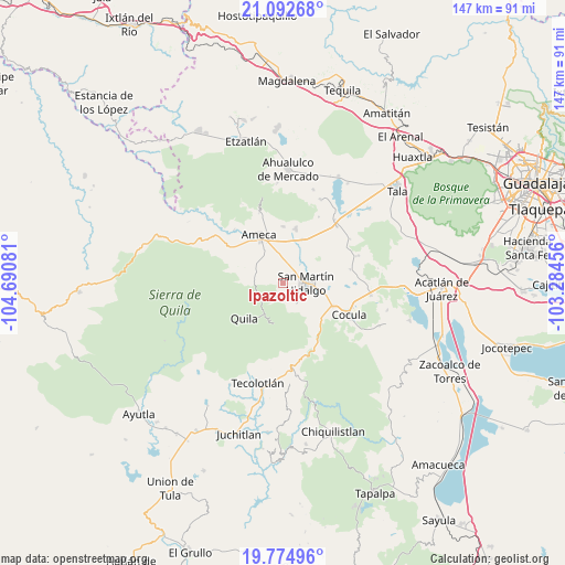
Ipazoltic GPS coordinates[2]
20° 26' 6.828" North, 103° 59' 15.648" West
| Map corner | latitude | longitude |
|---|---|---|
| Upper-left | 21.09268°, | -104.69081° |
| Center: | 20.43523°, | -103.98768° |
| Lower-right: | 19.77496°, | -103.28456° |
| Map W x H: | 146.5×146.5 km | = 91×91mi |
| max Lat: | 32.7° ⇑33.6% North |
| Ipazoltic: | 20.43523° |
| min Lat: | ⇓66.4% South 14.53588° |
| min Long | Ipazoltic | max Long |
| -117.105° | -103.98768° | -86.73105° |
| W 10.1%⇐ | ⇒89.9% E |
Elevation
Elevation of Ipazoltic is 1396 m = 4580 ft, and this is 142.3 m = 467 ft above average elevation for this country.
| Max E: |
3497 m = 11473 ft | 50.7% |
| Ipazoltic | 1396 m 4580 ft | |
| Avg. | 1253.7 m = 4113 ft | |
Min E: |
-1 m = -3 ft | 49.3% |
See also: Mexico elevation on elevation.city.
Geographical zone
Ipazoltic is located in North Torrid zone (between Equator and Tropic of Cancer). Distance of this Northern Tropic circle is 333.7 km =207.4 mi to North.| Distance of | km | miles | from Ipazoltic |
|---|---|---|---|
| North Pole | 7734.9 | 4806.2 | to North |
| Arctic Circle | 5129 | 3187 | to North |
| Tropic Cancer | 333.7 | 207.4 | to North |
| Equator | 2272.2 | 1411.9 | to South |


Nearby cities:
15 places around Ipazoltic: (largest is in red/bold)
• Ameca
13.7 km =8.5 mi,  334°
334°
• Buenos Aires
16.9 km =10.5 mi,  344°
344°
• El Cabezón
7.7 km =4.8 mi,  29°
29°
• El Crucero de Santa María
14.4 km =8.9 mi,  113°
113°
• El Salitre
15.9 km =9.9 mi,  58°
58°
• La Estanzuela
14.3 km =8.9 mi,  70°
70°
• Labor de Medina
7.6 km =4.7 mi,  52°
52°
• Labor de Solís
14.8 km =9.2 mi,  0°
0°
• Los Guerrero
9.4 km =5.8 mi,  85°
85°
• Los Pocitos
12.5 km =7.8 mi,  24°
24°
• San Martín Hidalgo
6.1 km =3.8 mi, 89°
• San Nicolás
17.9 km =11.1 mi,  78°
78°
• Santa Cruz de las Flores
6.1 km =3.8 mi,  138°
138°
• Santa María
14.7 km =9.1 mi, 105°
• Texcalame
9 km =5.6 mi,  284°
284°
Sources, notices
• [Note1] Compared only with cities in Mexico existing in our database
• [Src1] Map data: © OpenStreetMap contributors (CC-BY-SA)
• [Src2] Other city data from geonames.org with taken over terms of usage.
• [Src3] Geographical zone / Annual Mean Temperature by Robert A. Rohde @ Wikipedia
