Los Pocitos geodata
Los Pocitos (Jalisco) is a populated place; located in Mexico in America/Mexico_City (GMT-6) time zone. With population of 1,019 people, there are 8541 cities with bigger population in this country. Compared to other cities in Mexico, 68.6% of cities are located further ↓South; 89.8% of cities are located further →East and 53.9% of cities have higher elevation than Los Pocitos. Note1


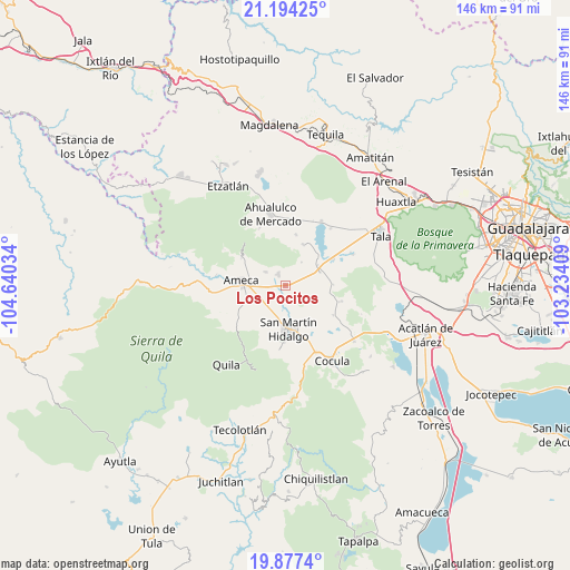
Los Pocitos GPS coordinates[2]
20° 32' 14.064" North, 103° 56' 13.956" West
| Map corner | latitude | longitude |
|---|---|---|
| Upper-left | 21.19425°, | -104.64034° |
| Center: | 20.53724°, | -103.93721° |
| Lower-right: | 19.8774°, | -103.23409° |
| Map W x H: | 146.4×146.4 km | = 91×91mi |
| max Lat: | 32.7° ⇑31.4% North |
| Los Pocitos: | 20.53724° |
| min Lat: | ⇓68.6% South 14.53588° |
| min Long | Los Pocitos | max Long |
| -117.105° | -103.93721° | -86.73105° |
| W 10.2%⇐ | ⇒89.8% E |
Elevation
Elevation of Los Pocitos is 1247 m = 4091 ft, and this is 6.7 m = 22 ft below average elevation for this country.
| Max E: |
3497 m = 11473 ft | 53.9% |
| Avg. | 1253.7 m = 4113 ft | |
| Los Pocitos | 1247 m = 4091 ft | |
Min E: |
-1 m = -3 ft | 46.1% |
See also: Mexico elevation on elevation.city.
Geographical zone
Los Pocitos is located in North Torrid zone (between Equator and Tropic of Cancer). Distance of this Northern Tropic circle is 322.4 km =200.3 mi to North.| Distance of | km | miles | from Los Pocitos |
|---|---|---|---|
| North Pole | 7723.5 | 4799.2 | to North |
| Arctic Circle | 5117.6 | 3179.9 | to North |
| Tropic Cancer | 322.4 | 200.3 | to North |
| Equator | 2283.5 | 1418.9 | to South |


Nearby cities:
15 places around Los Pocitos: (largest is in red/bold)
• Ameca
11.3 km =7 mi,  275°
275°
• Buenavista
9.5 km =5.9 mi,  68°
68°
• Buenos Aires
10.9 km =6.8 mi,  296°
296°
• El Amarillo
11.3 km =7 mi,  23°
23°
• El Cabezón
4.9 km =3 mi,  197°
197°
• El Salitre
8.8 km =5.5 mi,  109°
109°
• Ipazoltic
12.5 km =7.8 mi, 204°
• La Estanzuela
10.5 km =6.5 mi,  128°
128°
• La Vega
9.7 km =6 mi,  58°
58°
• Labor de Medina
6.8 km =4.2 mi,  172°
172°
• Labor de Solís
6.2 km =3.9 mi, 303°
• Los Guerrero
11.3 km =7 mi,  158°
158°
• Punta de la Vega
7.2 km =4.5 mi,  34°
34°
• San Martín Hidalgo
11.4 km =7.1 mi,  175°
175°
• Trapiche de Abra
12.2 km =7.6 mi,  88°
88°
Sources, notices
• [Note1] Compared only with cities in Mexico existing in our database
• [Src1] Map data: © OpenStreetMap contributors (CC-BY-SA)
• [Src2] Other city data from geonames.org with taken over terms of usage.
• [Src3] Geographical zone / Annual Mean Temperature by Robert A. Rohde @ Wikipedia
