Ameca geodata
Ameca (Jalisco) is a seat of a second-order administrative division; located in Mexico in America/Mexico_City (GMT-6) time zone. With population of 36,156 people, there are 282 cities with bigger population in this country. Compared to other cities in Mexico, 68.8% of cities are located further ↓South; 90.1% of cities are located further →East and 54.2% of cities have higher elevation than Ameca. Note1


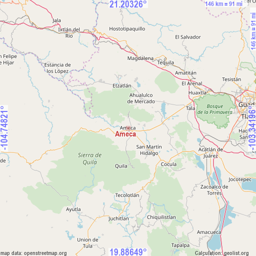
Ameca GPS coordinates[2]
20° 32' 46.644" North, 104° 2' 42.288" West
| Map corner | latitude | longitude |
|---|---|---|
| Upper-left | 21.20326°, | -104.74821° |
| Center: | 20.54629°, | -104.04508° |
| Lower-right: | 19.88649°, | -103.34196° |
| Map W x H: | 146.4×146.4 km | = 91×91mi |
| max Lat: | 32.7° ⇑31.2% North |
| Ameca: | 20.54629° |
| min Lat: | ⇓68.8% South 14.53588° |
| min Long | Ameca | max Long |
| -117.105° | -104.04508° | -86.73105° |
| W 9.9%⇐ | ⇒90.1% E |
Elevation
Elevation of Ameca is 1234 m = 4049 ft, and this is 19.7 m = 65 ft below average elevation for this country.
| Max E: |
3497 m = 11473 ft | 54.2% |
| Avg. | 1253.7 m = 4113 ft | |
| Ameca | 1234 m = 4049 ft | |
Min E: |
-1 m = -3 ft | 45.8% |
See also: Mexico elevation on elevation.city.
Geographical zone
Ameca is located in North Torrid zone (between Equator and Tropic of Cancer). Distance of this Northern Tropic circle is 321.4 km =199.7 mi to North.| Distance of | km | miles | from Ameca |
|---|---|---|---|
| North Pole | 7722.5 | 4798.5 | to North |
| Arctic Circle | 5116.6 | 3179.3 | to North |
| Tropic Cancer | 321.4 | 199.7 | to North |
| Equator | 2284.5 | 1419.5 | to South |


Nearby cities:
15 places around Ameca: (largest is in red/bold)
• Buenos Aires
4.2 km =2.6 mi,  20°
20°
• El Cabezón
11.3 km =7 mi,  119°
119°
• El Portezuelo
5.9 km =3.7 mi,  358°
358°
• Ipazoltic
13.7 km =8.5 mi,  154°
154°
• Jayamitla
14.7 km =9.1 mi,  289°
289°
• La Villita
14 km =8.7 mi, 288°
• Labor de Medina
14.3 km =8.9 mi, 122°
• Labor de Solís
6.6 km =4.1 mi,  68°
68°
• Los Pocitos
11.3 km =7 mi,  95°
95°
• Portes Gil
16.7 km =10.4 mi,  41°
41°
• Punta de la Vega
16.1 km =10 mi, 72°
• San Martín Hidalgo
17.3 km =10.7 mi,  135°
135°
• San Nicolás
6.8 km =4.2 mi,  283°
283°
• Santa Cruz de Bárcenas
14.3 km =8.9 mi, 18°
• Texcalame
10.5 km =6.5 mi,  195°
195°
Sources, notices
• [Note1] Compared only with cities in Mexico existing in our database
• [Src1] Map data: © OpenStreetMap contributors (CC-BY-SA)
• [Src2] Other city data from geonames.org with taken over terms of usage.
• [Src3] Geographical zone / Annual Mean Temperature by Robert A. Rohde @ Wikipedia
