El Cabezón geodata
El Cabezón (Jalisco) is a populated place; located in Mexico in America/Mexico_City (GMT-6) time zone. With population of 2,683 people, there are 3296 cities with bigger population in this country. Compared to other cities in Mexico, 67.7% of cities are located further ↓South; 89.8% of cities are located further →East and 53.5% of cities have higher elevation than El Cabezón. Note1


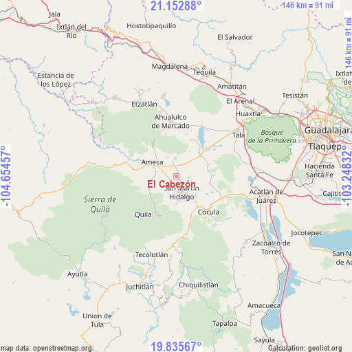
El Cabezón GPS coordinates[2]
20° 29' 44.484" North, 103° 57' 5.184" West
| Map corner | latitude | longitude |
|---|---|---|
| Upper-left | 21.15288°, | -104.65457° |
| Center: | 20.49569°, | -103.95144° |
| Lower-right: | 19.83567°, | -103.24832° |
| Map W x H: | 146.5×146.5 km | = 91×91mi |
| max Lat: | 32.7° ⇑32.3% North |
| El Cabezón: | 20.49569° |
| min Lat: | ⇓67.7% South 14.53588° |
| min Long | El Cabezón | max Long |
| -117.105° | -103.95144° | -86.73105° |
| W 10.2%⇐ | ⇒89.8% E |
Elevation
Elevation of El Cabezón is 1270 m = 4167 ft, and this is 16.3 m = 53 ft above average elevation for this country.
| Max E: |
3497 m = 11473 ft | 53.5% |
| El Cabezón | 1270 m 4167 ft | |
| Avg. | 1253.7 m = 4113 ft | |
Min E: |
-1 m = -3 ft | 46.5% |
See also: Mexico elevation on elevation.city.
Geographical zone
El Cabezón is located in North Torrid zone (between Equator and Tropic of Cancer). Distance of this Northern Tropic circle is 327 km =203.2 mi to North.| Distance of | km | miles | from El Cabezón |
|---|---|---|---|
| North Pole | 7728.2 | 4802.1 | to North |
| Arctic Circle | 5122.3 | 3182.8 | to North |
| Tropic Cancer | 327 | 203.2 | to North |
| Equator | 2278.9 | 1416 | to South |


Nearby cities:
15 places around El Cabezón: (largest is in red/bold)
• Ameca
11.3 km =7 mi,  299°
299°
• Buenavista
13.1 km =8.1 mi,  52°
52°
• Buenos Aires
12.6 km =7.8 mi,  319°
319°
• El Salitre
9.9 km =6.2 mi,  80°
80°
• Ipazoltic
7.7 km =4.8 mi,  209°
209°
• La Estanzuela
9.9 km =6.2 mi,  101°
101°
• La Vega
13.7 km =8.5 mi,  44°
44°
• Labor de Medina
3.1 km =1.9 mi,  132°
132°
• Labor de Solís
8.8 km =5.5 mi,  335°
335°
• Los Guerrero
8.1 km =5 mi,  136°
136°
• Los Pocitos
4.9 km =3 mi,  17°
17°
• Punta de la Vega
11.9 km =7.4 mi,  27°
27°
• San Martín Hidalgo
7.1 km =4.4 mi,  160°
160°
• Santa Cruz de las Flores
11.3 km =7 mi,  178°
178°
• Texcalame
13.3 km =8.3 mi,  250°
250°
Sources, notices
• [Note1] Compared only with cities in Mexico existing in our database
• [Src1] Map data: © OpenStreetMap contributors (CC-BY-SA)
• [Src2] Other city data from geonames.org with taken over terms of usage.
• [Src3] Geographical zone / Annual Mean Temperature by Robert A. Rohde @ Wikipedia
