San Gregorio geodata
San Gregorio (Michoacán) is a populated place; located in Mexico in America/Mexico_City (GMT-6) time zone. With population of 2,087 people, there are 4183 cities with bigger population in this country. Compared to other cities in Mexico, 61.2% of cities are located further ↓South; 84.3% of cities are located further →East and 52.4% of cities have lower elevation than San Gregorio. Note1


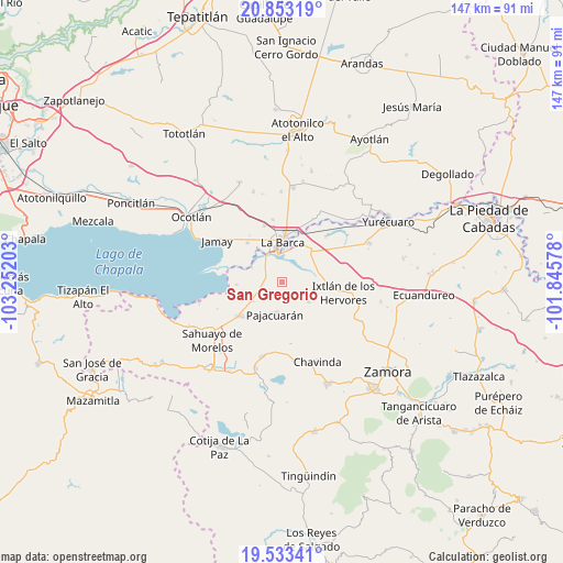
San Gregorio GPS coordinates[2]
20° 11' 40.92" North, 102° 32' 56.04" West
| Map corner | latitude | longitude |
|---|---|---|
| Upper-left | 20.85319°, | -103.25203° |
| Center: | 20.1947°, | -102.5489° |
| Lower-right: | 19.53341°, | -101.84578° |
| Map W x H: | 146.7×146.7 km | = 91.2×91.2mi |
| max Lat: | 32.7° ⇑38.8% North |
| San Gregorio: | 20.1947° |
| min Lat: | ⇓61.2% South 14.53588° |
| min Long | San Gregorio | max Long |
| -117.105° | -102.5489° | -86.73105° |
| W 15.7%⇐ | ⇒84.3% E |
Elevation
Elevation of San Gregorio is 1531 m = 5023 ft, and this is 277.3 m = 910 ft above average elevation for this country.
| Max E: |
3497 m = 11473 ft | 47.6% |
| San Gregorio | 1531 m 5023 ft | |
| Avg. | 1253.7 m = 4113 ft | |
Min E: |
-1 m = -3 ft | 52.4% |
See also: Mexico elevation on elevation.city.
Geographical zone
San Gregorio is located in North Torrid zone (between Equator and Tropic of Cancer). Distance of this Northern Tropic circle is 360.5 km =224 mi to North.| Distance of | km | miles | from San Gregorio |
|---|---|---|---|
| North Pole | 7761.6 | 4822.8 | to North |
| Arctic Circle | 5155.7 | 3203.6 | to North |
| Tropic Cancer | 360.5 | 224 | to North |
| Equator | 2245.4 | 1395.2 | to South |


Nearby cities:
15 places around San Gregorio: (largest is in red/bold)
• Briseñas de Matamoros
8.3 km =5.2 mi,  350°
350°
• Cumuato
8.2 km =5.1 mi,  327°
327°
• El Capulín
7.2 km =4.5 mi,  59°
59°
• El Fortín
5.6 km =3.5 mi,  253°
253°
• El Paracho
10 km =6.2 mi,  164°
164°
• El Valenciano
10.9 km =6.8 mi,  117°
117°
• Ibarra
8.7 km =5.4 mi,  296°
296°
• La Barca
10.4 km =6.5 mi,  2°
2°
• La Luz
8.1 km =5 mi,  125°
125°
• Morelos
9.2 km =5.7 mi,  236°
236°
• Pajacuarán
8.6 km =5.3 mi,  192°
192°
• Paso de Hidalgo (Paso de Álamos)
8.7 km =5.4 mi, 2°
• Pueblo Viejo
9.8 km =6.1 mi,  218°
218°
• San Pedro de Ruíz
10.5 km =6.5 mi, 347°
• Tecomatán
10.4 km =6.5 mi,  148°
148°
Sources, notices
• [Note1] Compared only with cities in Mexico existing in our database
• [Src1] Map data: © OpenStreetMap contributors (CC-BY-SA)
• [Src2] Other city data from geonames.org with taken over terms of usage.
• [Src3] Geographical zone / Annual Mean Temperature by Robert A. Rohde @ Wikipedia
