Huanímaro geodata
Huanímaro (Guanajuato) is a seat of a second-order administrative division; located in Mexico in America/Mexico_City (GMT-6) time zone. With population of 5,505 people, there are 1694 cities with bigger population in this country. Compared to other cities in Mexico, 64.9% of cities are located further ↓South; 77.4% of cities are located further →East and 59.6% of cities have lower elevation than Huanímaro. Note1


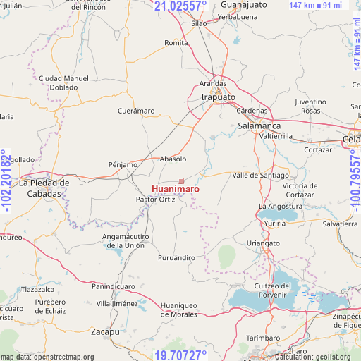
Huanímaro GPS coordinates[2]
20° 22' 4.188" North, 101° 29' 55.284" West
| Map corner | latitude | longitude |
|---|---|---|
| Upper-left | 21.02557°, | -102.20182° |
| Center: | 20.36783°, | -101.49869° |
| Lower-right: | 19.70727°, | -100.79557° |
| Map W x H: | 146.6×146.6 km | = 91.1×91.1mi |
| max Lat: | 32.7° ⇑35.1% North |
| Huanímaro: | 20.36783° |
| min Lat: | ⇓64.9% South 14.53588° |
| min Long | Huanímaro | max Long |
| -117.105° | -101.49869° | -86.73105° |
| W 22.6%⇐ | ⇒77.4% E |
Elevation
Elevation of Huanímaro is 1719 m = 5640 ft, and this is 465.3 m = 1527 ft above average elevation for this country.
| Max E: |
3497 m = 11473 ft | 40.4% |
| Huanímaro | 1719 m 5640 ft | |
| Avg. | 1253.7 m = 4113 ft | |
Min E: |
-1 m = -3 ft | 59.6% |
See also: Mexico elevation on elevation.city.
Geographical zone
Huanímaro is located in North Torrid zone (between Equator and Tropic of Cancer). Distance of this Northern Tropic circle is 341.2 km =212 mi to North.| Distance of | km | miles | from Huanímaro |
|---|---|---|---|
| North Pole | 7742.4 | 4810.9 | to North |
| Arctic Circle | 5136.5 | 3191.7 | to North |
| Tropic Cancer | 341.2 | 212 | to North |
| Equator | 2264.7 | 1407.2 | to South |


Nearby cities:
15 places around Huanímaro: (largest is in red/bold)
• Boquillas
8.7 km =5.4 mi,  51°
51°
• Cora
5.2 km =3.2 mi,  141°
141°
• El Novillero
8.5 km =5.3 mi,  290°
290°
• Guarapo
9.2 km =5.7 mi,  79°
79°
• Héroes de Chapultepec (Rodeo de San Antonio)
6.3 km =3.9 mi,  183°
183°
• Joroches (Joroches Nuevo)
4.4 km =2.7 mi,  194°
194°
• La Lobera
4.5 km =2.8 mi,  256°
256°
• Las Raíces
7 km =4.3 mi,  100°
100°
• Monte Blanco
3.3 km =2.1 mi,  244°
244°
• Ojos de Agua
7.9 km =4.9 mi, 287°
• Otates
4.1 km =2.5 mi,  25°
25°
• Rancho de Guadalupe (El Gato)
6.8 km =4.2 mi,  247°
247°
• Salitre de Aguilares
8 km =5 mi,  134°
134°
• San José de Ayala
6.3 km =3.9 mi,  70°
70°
• San Juan Grande
3.1 km =1.9 mi, 287°
Sources, notices
• [Note1] Compared only with cities in Mexico existing in our database
• [Src1] Map data: © OpenStreetMap contributors (CC-BY-SA)
• [Src2] Other city data from geonames.org with taken over terms of usage.
• [Src3] Geographical zone / Annual Mean Temperature by Robert A. Rohde @ Wikipedia
