Otates geodata
Otates (Guanajuato) is a populated place; located in Mexico in America/Mexico_City (GMT-6) time zone. With population of 1,199 people, there are 7246 cities with bigger population in this country. Compared to other cities in Mexico, 65.7% of cities are located further ↓South; 77.3% of cities are located further →East and 66.9% of cities have lower elevation than Otates. Note1


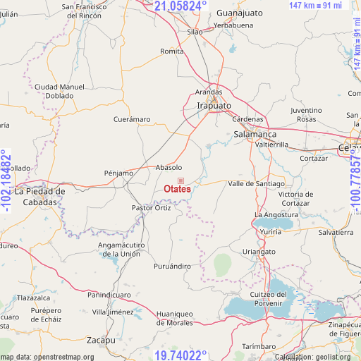
Otates GPS coordinates[2]
20° 24' 2.304" North, 101° 28' 54.084" West
| Map corner | latitude | longitude |
|---|---|---|
| Upper-left | 21.05824°, | -102.18482° |
| Center: | 20.40064°, | -101.48169° |
| Lower-right: | 19.74022°, | -100.77857° |
| Map W x H: | 146.6×146.6 km | = 91.1×91.1mi |
| max Lat: | 32.7° ⇑34.3% North |
| Otates: | 20.40064° |
| min Lat: | ⇓65.7% South 14.53588° |
| min Long | Otates | max Long |
| -117.105° | -101.48169° | -86.73105° |
| W 22.7%⇐ | ⇒77.3% E |
Elevation
Elevation of Otates is 1868 m = 6129 ft, and this is 614.3 m = 2015 ft above average elevation for this country.
| Max E: |
3497 m = 11473 ft | 33.1% |
| Otates | 1868 m 6129 ft | |
| Avg. | 1253.7 m = 4113 ft | |
Min E: |
-1 m = -3 ft | 66.9% |
See also: Mexico elevation on elevation.city.
Geographical zone
Otates is located in North Torrid zone (between Equator and Tropic of Cancer). Distance of this Northern Tropic circle is 337.6 km =209.8 mi to North.| Distance of | km | miles | from Otates |
|---|---|---|---|
| North Pole | 7738.7 | 4808.6 | to North |
| Arctic Circle | 5132.8 | 3189.4 | to North |
| Tropic Cancer | 337.6 | 209.8 | to North |
| Equator | 2268.3 | 1409.5 | to South |


Nearby cities:
15 places around Otates: (largest is in red/bold)
• Abasolo
7.5 km =4.7 mi,  317°
317°
• Boquillas
5.3 km =3.3 mi,  70°
70°
• Cora
7.9 km =4.9 mi,  169°
169°
• Guarapo
7.6 km =4.7 mi,  105°
105°
• Huanímaro
4.1 km =2.5 mi,  205°
205°
• Joroches (Joroches Nuevo)
8.4 km =5.2 mi,  199°
199°
• La Lobera
7.7 km =4.8 mi,  232°
232°
• La Tinaja de Negrete
6.3 km =3.9 mi,  17°
17°
• Labor de Peralta
7.6 km =4.7 mi,  83°
83°
• Las Raíces
7.2 km =4.5 mi,  134°
134°
• Monte Blanco
7 km =4.3 mi,  223°
223°
• San Bernardo Peña Blanca
6.8 km =4.2 mi,  359°
359°
• San Isidro
7.1 km =4.4 mi,  349°
349°
• San José de Ayala
4.5 km =2.8 mi, 109°
• San Juan Grande
5.4 km =3.4 mi,  240°
240°
Sources, notices
• [Note1] Compared only with cities in Mexico existing in our database
• [Src1] Map data: © OpenStreetMap contributors (CC-BY-SA)
• [Src2] Other city data from geonames.org with taken over terms of usage.
• [Src3] Geographical zone / Annual Mean Temperature by Robert A. Rohde @ Wikipedia
