La Lobera geodata
La Lobera (Guanajuato) is a populated place; located in Mexico in America/Mexico_City (GMT-6) time zone. With population of 1,631 people, there are 5309 cities with bigger population in this country. Compared to other cities in Mexico, 64.7% of cities are located further ↓South; 77.7% of cities are located further →East and 58.4% of cities have lower elevation than La Lobera. Note1


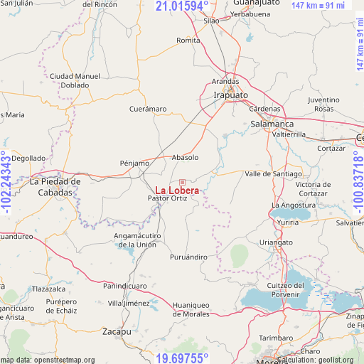
La Lobera GPS coordinates[2]
20° 21' 29.34" North, 101° 32' 25.08" West
| Map corner | latitude | longitude |
|---|---|---|
| Upper-left | 21.01594°, | -102.24343° |
| Center: | 20.35815°, | -101.5403° |
| Lower-right: | 19.69755°, | -100.83718° |
| Map W x H: | 146.6×146.6 km | = 91.1×91.1mi |
| max Lat: | 32.7° ⇑35.3% North |
| La Lobera: | 20.35815° |
| min Lat: | ⇓64.7% South 14.53588° |
| min Long | La Lobera | max Long |
| -117.105° | -101.5403° | -86.73105° |
| W 22.3%⇐ | ⇒77.7% E |
Elevation
Elevation of La Lobera is 1696 m = 5564 ft, and this is 442.3 m = 1451 ft above average elevation for this country.
| Max E: |
3497 m = 11473 ft | 41.6% |
| La Lobera | 1696 m 5564 ft | |
| Avg. | 1253.7 m = 4113 ft | |
Min E: |
-1 m = -3 ft | 58.4% |
See also: Mexico elevation on elevation.city.
Geographical zone
La Lobera is located in North Torrid zone (between Equator and Tropic of Cancer). Distance of this Northern Tropic circle is 342.3 km =212.7 mi to North.| Distance of | km | miles | from La Lobera |
|---|---|---|---|
| North Pole | 7743.4 | 4811.5 | to North |
| Arctic Circle | 5137.6 | 3192.4 | to North |
| Tropic Cancer | 342.3 | 212.7 | to North |
| Equator | 2263.6 | 1406.5 | to South |


Nearby cities:
15 places around La Lobera: (largest is in red/bold)
• Cora
8.2 km =5.1 mi,  111°
111°
• El Novillero
5.4 km =3.4 mi,  318°
318°
• El Varal
6.3 km =3.9 mi,  260°
260°
• Huanímaro
4.5 km =2.8 mi,  76°
76°
• Héroes de Chapultepec (Rodeo de San Antonio)
6.5 km =4 mi,  143°
143°
• Joroches (Joroches Nuevo)
4.5 km =2.8 mi,  134°
134°
• Los Corrales
5.8 km =3.6 mi,  215°
215°
• Maritas
7.9 km =4.9 mi,  233°
233°
• Monte Blanco
1.4 km =0.9 mi, 105°
• Ojos de Agua
4.7 km =2.9 mi, 317°
• Otates
7.7 km =4.8 mi,  52°
52°
• Pastor Ortíz
8.2 km =5.1 mi, 224°
• Rancho de Guadalupe (El Gato)
2.5 km =1.6 mi, 232°
• Rincón de Martínez
5.2 km =3.2 mi, 229°
• San Juan Grande
2.5 km =1.6 mi,  34°
34°
Sources, notices
• [Note1] Compared only with cities in Mexico existing in our database
• [Src1] Map data: © OpenStreetMap contributors (CC-BY-SA)
• [Src2] Other city data from geonames.org with taken over terms of usage.
• [Src3] Geographical zone / Annual Mean Temperature by Robert A. Rohde @ Wikipedia
