Escalerillas geodata
Escalerillas (San Luis Potosí) is a populated place; located in Mexico in America/Mexico_City (GMT-6) time zone. With population of 4,778 people, there are 1934 cities with bigger population in this country. Compared to other cities in Mexico, 84.8% of cities are located further ↓South; 74% of cities are located further →East and 71.4% of cities have lower elevation than Escalerillas. Note1


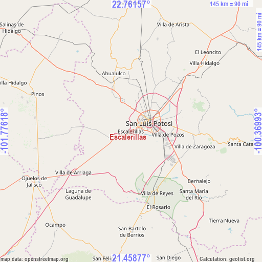
Escalerillas GPS coordinates[2]
22° 6' 42.012" North, 101° 4' 22.98" West
| Map corner | latitude | longitude |
|---|---|---|
| Upper-left | 22.76157°, | -101.77618° |
| Center: | 22.11167°, | -101.07305° |
| Lower-right: | 21.45877°, | -100.36993° |
| Map W x H: | 144.9×144.9 km | = 90×90mi |
| max Lat: | 32.7° ⇑15.2% North |
| Escalerillas: | 22.11167° |
| min Lat: | ⇓84.8% South 14.53588° |
| min Long | Escalerillas | max Long |
| -117.105° | -101.07305° | -86.73105° |
| W 26%⇐ | ⇒74% E |
Elevation
Elevation of Escalerillas is 1955 m = 6414 ft, and this is 701.3 m = 2301 ft above average elevation for this country.
| Max E: |
3497 m = 11473 ft | 28.6% |
| Escalerillas | 1955 m 6414 ft | |
| Avg. | 1253.7 m = 4113 ft | |
Min E: |
-1 m = -3 ft | 71.4% |
See also: Mexico elevation on elevation.city.
Geographical zone
Escalerillas is located in North Torrid zone (between Equator and Tropic of Cancer). Distance of this Northern Tropic circle is 147.3 km =91.5 mi to North.| Distance of | km | miles | from Escalerillas |
|---|---|---|---|
| North Pole | 7548.5 | 4690.4 | to North |
| Arctic Circle | 4942.6 | 3071.2 | to North |
| Tropic Cancer | 147.3 | 91.5 | to North |
| Equator | 2458.6 | 1527.7 | to South |


Nearby cities:
15 places around Escalerillas: (largest is in red/bold)
• Capulines
7.6 km =4.7 mi,  17°
17°
• Cerrito de Jaral
12.5 km =7.8 mi,  4°
4°
• Colonia Insurgentes
2.5 km =1.6 mi,  71°
71°
• El Jaralito
10.1 km =6.3 mi,  14°
14°
• Fracción la Angostura Norte
13 km =8.1 mi,  33°
33°
• Guadalupe Victoria
5.8 km =3.6 mi, 3°
• La Loma
11.6 km =7.2 mi, 11°
• La Mesa de los Conejos
2.3 km =1.4 mi,  114°
114°
• Monte Obscuro
12.8 km =8 mi, 20°
• Paisanos
10.9 km =6.8 mi, 20°
• Paso Blanco
10.5 km =6.5 mi, 1°
• Pozuelos
5 km =3.1 mi,  240°
240°
• San Antonio
12.4 km =7.7 mi, 239°
• San Luis Potosí
10.6 km =6.6 mi, 66°
• Suspiro Picacho
11.1 km =6.9 mi,  353°
353°
Sources, notices
• [Note1] Compared only with cities in Mexico existing in our database
• [Src1] Map data: © OpenStreetMap contributors (CC-BY-SA)
• [Src2] Other city data from geonames.org with taken over terms of usage.
• [Src3] Geographical zone / Annual Mean Temperature by Robert A. Rohde @ Wikipedia
