Erongarícuaro geodata
Erongarícuaro (Michoacán) is a seat of a second-order administrative division; located in Mexico in America/Mexico_City (GMT-6) time zone. With population of 2,573 people, there are 3442 cities with bigger population in this country. Compared to other cities in Mexico, 52.1% of cities are located further ↑North; 79.2% of cities are located further →East and 77.6% of cities have lower elevation than Erongarícuaro. Note1


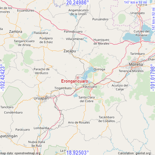
Erongarícuaro GPS coordinates[2]
19° 35' 19.716" North, 101° 43' 15.96" West
| Map corner | latitude | longitude |
|---|---|---|
| Upper-left | 20.24986°, | -102.42423° |
| Center: | 19.58881°, | -101.7211° |
| Lower-right: | 18.92503°, | -101.01798° |
| Map W x H: | 147.3×147.3 km | = 91.5×91.5mi |
| max Lat: | 32.7° ⇑52.1% North |
| Erongarícuaro: | 19.58881° |
| min Lat: | ⇓47.9% South 14.53588° |
| min Long | Erongarícuaro | max Long |
| -117.105° | -101.7211° | -86.73105° |
| W 20.8%⇐ | ⇒79.2% E |
Elevation
Elevation of Erongarícuaro is 2080 m = 6824 ft, and this is 826.3 m = 2711 ft above average elevation for this country.
| Max E: |
3497 m = 11473 ft | 22.4% |
| Erongarícuaro | 2080 m 6824 ft | |
| Avg. | 1253.7 m = 4113 ft | |
Min E: |
-1 m = -3 ft | 77.6% |
See also: Mexico elevation on elevation.city.
Geographical zone
Erongarícuaro is located in North Torrid zone (between Equator and Tropic of Cancer). Distance of this Northern Tropic circle is 427.8 km =265.8 mi to North.| Distance of | km | miles | from Erongarícuaro |
|---|---|---|---|
| North Pole | 7829 | 4864.7 | to North |
| Arctic Circle | 5223.1 | 3245.5 | to North |
| Tropic Cancer | 427.8 | 265.8 | to North |
| Equator | 2178.1 | 1353.4 | to South |


Nearby cities:
15 places around Erongarícuaro: (largest is in red/bold)
• Ajuno
8.5 km =5.3 mi,  181°
181°
• Arocutín
4.4 km =2.7 mi,  143°
143°
• Cucuchucho
9.5 km =5.9 mi,  94°
94°
• Janitzio
7.5 km =4.7 mi,  103°
103°
• Jarácuaro
5.5 km =3.4 mi,  124°
124°
• Lázaro Cárdenas (Colonia de Lázaro Cárdenas)
10.7 km =6.6 mi,  345°
345°
• Napízaro
3.1 km =1.9 mi,  71°
71°
• Pichátaro
9.2 km =5.7 mi,  258°
258°
• Puácuaro
5.2 km =3.2 mi, 72°
• San Miguel Nocutzepo
7 km =4.3 mi,  160°
160°
• San Pedro Pareo
8.2 km =5.1 mi, 139°
• Santa Ana Chapitiro
10 km =6.2 mi,  134°
134°
• Santa María Huiramangaro (San Juan Tumbio)
9.6 km =6 mi,  208°
208°
• Tócuaro
6.2 km =3.9 mi,  153°
153°
• Uricho
2 km =1.2 mi,  165°
165°
Sources, notices
• [Note1] Compared only with cities in Mexico existing in our database
• [Src1] Map data: © OpenStreetMap contributors (CC-BY-SA)
• [Src2] Other city data from geonames.org with taken over terms of usage.
• [Src3] Geographical zone / Annual Mean Temperature by Robert A. Rohde @ Wikipedia
