Puácuaro geodata
Puácuaro (Michoacán) is a populated place; located in Mexico in America/Mexico_City (GMT-6) time zone. With population of 1,807 people, there are 4820 cities with bigger population in this country. Compared to other cities in Mexico, 51.8% of cities are located further ↑North; 78.8% of cities are located further →East and 77.2% of cities have lower elevation than Puácuaro. Note1


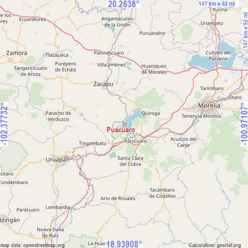
Puácuaro GPS coordinates[2]
19° 36' 10.08" North, 101° 40' 27.084" West
| Map corner | latitude | longitude |
|---|---|---|
| Upper-left | 20.2638°, | -102.37732° |
| Center: | 19.6028°, | -101.67419° |
| Lower-right: | 18.93908°, | -100.97107° |
| Map W x H: | 147.3×147.3 km | = 91.5×91.5mi |
| max Lat: | 32.7° ⇑51.8% North |
| Puácuaro: | 19.6028° |
| min Lat: | ⇓48.2% South 14.53588° |
| min Long | Puácuaro | max Long |
| -117.105° | -101.67419° | -86.73105° |
| W 21.2%⇐ | ⇒78.8% E |
Elevation
Elevation of Puácuaro is 2073 m = 6801 ft, and this is 819.3 m = 2688 ft above average elevation for this country.
| Max E: |
3497 m = 11473 ft | 22.8% |
| Puácuaro | 2073 m 6801 ft | |
| Avg. | 1253.7 m = 4113 ft | |
Min E: |
-1 m = -3 ft | 77.2% |
See also: Mexico elevation on elevation.city.
Geographical zone
Puácuaro is located in North Torrid zone (between Equator and Tropic of Cancer). Distance of this Northern Tropic circle is 426.3 km =264.9 mi to North.| Distance of | km | miles | from Puácuaro |
|---|---|---|---|
| North Pole | 7827.4 | 4863.7 | to North |
| Arctic Circle | 5221.5 | 3244.5 | to North |
| Tropic Cancer | 426.3 | 264.9 | to North |
| Equator | 2179.6 | 1354.3 | to South |


Nearby cities:
15 places around Puácuaro: (largest is in red/bold)
• Arocutín
5.6 km =3.5 mi,  203°
203°
• Cucuchucho
5 km =3.1 mi,  116°
116°
• Erongarícuaro
5.2 km =3.2 mi,  252°
252°
• Huecorio
8.4 km =5.2 mi,  149°
149°
• Ihuatzio
7.3 km =4.5 mi, 123°
• Janitzio
4 km =2.5 mi,  144°
144°
• Jarácuaro
4.7 km =2.9 mi,  184°
184°
• Napízaro
2.1 km =1.3 mi, 253°
• San Andrés Ziróndaro
8.6 km =5.3 mi,  30°
30°
• San Miguel Nocutzepo
8.5 km =5.3 mi, 197°
• San Pedro Pareo
7.8 km =4.8 mi, 177°
• Santa Ana Chapitiro
8.8 km =5.5 mi,  165°
165°
• Tzintzuntzán
10.4 km =6.5 mi,  74°
74°
• Tócuaro
7.4 km =4.6 mi, 196°
• Uricho
5.6 km =3.5 mi,  231°
231°
Sources, notices
• [Note1] Compared only with cities in Mexico existing in our database
• [Src1] Map data: © OpenStreetMap contributors (CC-BY-SA)
• [Src2] Other city data from geonames.org with taken over terms of usage.
• [Src3] Geographical zone / Annual Mean Temperature by Robert A. Rohde @ Wikipedia
