Napízaro geodata
Napízaro (Michoacán) is a populated place; located in Mexico in America/Mexico_City (GMT-6) time zone. With population of 520 people, there are 16208 cities with bigger population in this country. Compared to other cities in Mexico, 51.9% of cities are located further ↑North; 78.9% of cities are located further →East and 77% of cities have lower elevation than Napízaro. Note1


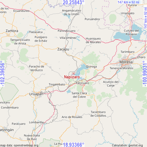
Napízaro GPS coordinates[2]
19° 35' 50.676" North, 101° 41' 36.348" West
| Map corner | latitude | longitude |
|---|---|---|
| Upper-left | 20.25843°, | -102.39656° |
| Center: | 19.59741°, | -101.69343° |
| Lower-right: | 18.93366°, | -100.99031° |
| Map W x H: | 147.3×147.3 km | = 91.5×91.5mi |
| max Lat: | 32.7° ⇑51.9% North |
| Napízaro: | 19.59741° |
| min Lat: | ⇓48.1% South 14.53588° |
| min Long | Napízaro | max Long |
| -117.105° | -101.69343° | -86.73105° |
| W 21.1%⇐ | ⇒78.9% E |
Elevation
Elevation of Napízaro is 2069 m = 6788 ft, and this is 815.3 m = 2675 ft above average elevation for this country.
| Max E: |
3497 m = 11473 ft | 23% |
| Napízaro | 2069 m 6788 ft | |
| Avg. | 1253.7 m = 4113 ft | |
Min E: |
-1 m = -3 ft | 77% |
See also: Mexico elevation on elevation.city.
Geographical zone
Napízaro is located in North Torrid zone (between Equator and Tropic of Cancer). Distance of this Northern Tropic circle is 426.9 km =265.3 mi to North.| Distance of | km | miles | from Napízaro |
|---|---|---|---|
| North Pole | 7828 | 4864.1 | to North |
| Arctic Circle | 5222.1 | 3244.9 | to North |
| Tropic Cancer | 426.9 | 265.3 | to North |
| Equator | 2179 | 1354 | to South |


Nearby cities:
15 places around Napízaro: (largest is in red/bold)
• Ajuno
9.9 km =6.2 mi,  198°
198°
• Arocutín
4.5 km =2.8 mi,  183°
183°
• Cucuchucho
6.7 km =4.2 mi,  104°
104°
• Erongarícuaro
3.1 km =1.9 mi,  251°
251°
• Huecorio
9.1 km =5.7 mi,  136°
136°
• Ihuatzio
8.8 km =5.5 mi,  113°
113°
• Janitzio
5.1 km =3.2 mi,  121°
121°
• Jarácuaro
4.4 km =2.7 mi,  158°
158°
• Puácuaro
2.1 km =1.3 mi,  73°
73°
• San Andrés Ziróndaro
10.3 km =6.4 mi,  38°
38°
• San Miguel Nocutzepo
7.5 km =4.7 mi, 184°
• San Pedro Pareo
7.6 km =4.7 mi, 161°
• Santa Ana Chapitiro
9 km =5.6 mi,  151°
151°
• Tócuaro
6.5 km =4 mi, 181°
• Uricho
3.8 km =2.4 mi,  219°
219°
Sources, notices
• [Note1] Compared only with cities in Mexico existing in our database
• [Src1] Map data: © OpenStreetMap contributors (CC-BY-SA)
• [Src2] Other city data from geonames.org with taken over terms of usage.
• [Src3] Geographical zone / Annual Mean Temperature by Robert A. Rohde @ Wikipedia
