Bachíniva geodata
Bachíniva (Chihuahua) is a seat of a second-order administrative division; located in Mexico in America/Chihuahua (GMT-6) time zone. With population of 2,109 people, there are 4142 cities with bigger population in this country. Compared to other cities in Mexico, 97.9% of cities are located further ↓South; 94.6% of cities are located further →East and 74.5% of cities have lower elevation than Bachíniva. Note1


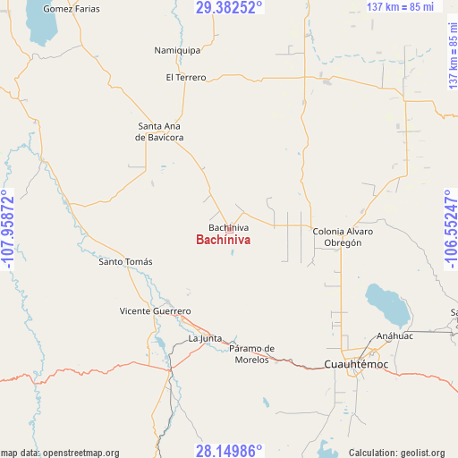
Bachíniva GPS coordinates[2]
28° 46' 4.836" North, 107° 15' 20.124" West
| Map corner | latitude | longitude |
|---|---|---|
| Upper-left | 29.38252°, | -107.95872° |
| Center: | 28.76801°, | -107.25559° |
| Lower-right: | 28.14986°, | -106.55247° |
| Map W x H: | 137.1×137.1 km | = 85.2×85.2mi |
| max Lat: | 32.7° ⇑2.1% North |
| Bachíniva: | 28.76801° |
| min Lat: | ⇓97.9% South 14.53588° |
| min Long | Bachíniva | max Long |
| -117.105° | -107.25559° | -86.73105° |
| W 5.4%⇐ | ⇒94.6% E |
Elevation
Elevation of Bachíniva is 2021 m = 6631 ft, and this is 767.3 m = 2517 ft above average elevation for this country.
| Max E: |
3497 m = 11473 ft | 25.5% |
| Bachíniva | 2021 m 6631 ft | |
| Avg. | 1253.7 m = 4113 ft | |
Min E: |
-1 m = -3 ft | 74.5% |
See also: Mexico elevation on elevation.city.
Geographical zone
Bachíniva is located in North temperate zone (between Tropic of Cancer and the Arctic Circle). Distance of this Northern Tropic circle is 592.8 km =368.3 mi to South.| Distance of | km | miles | from Bachíniva |
|---|---|---|---|
| North Pole | 6808.4 | 4230.5 | to North |
| Arctic Circle | 4202.5 | 2611.3 | to North |
| Tropic Cancer | 592.8 | 368.3 | to South |
| Equator | 3198.7 | 1987.6 | to South |


Nearby cities:
15 places around Bachíniva: (largest is in red/bold)
• Abraham González
28.7 km =17.8 mi,  323°
323°
• Adolfo López Mateos
33.8 km =21 mi,  187°
187°
• Basúchil
30.6 km =19 mi,  207°
207°
• Borjas
30.7 km =19.1 mi, 211°
• Colonia Margarita Maza de Juárez
35.4 km =22 mi,  92°
92°
• Ejido La Quemada
24.5 km =15.2 mi,  68°
68°
• Granjas el Venado
36.6 km =22.7 mi, 92°
• Guerrero
33 km =20.5 mi,  222°
222°
• La Junta
32.8 km =20.4 mi, 192°
• Lázaro Cárdenas
44.2 km =27.5 mi,  30°
30°
• Oscar Soto Maynez
35.9 km =22.3 mi, 324°
• Paramo
38 km =23.6 mi,  169°
169°
• Pedernales
42.1 km =26.2 mi,  160°
160°
• Santo Tomás
32.4 km =20.1 mi,  252°
252°
• Sáenz
31.3 km =19.4 mi,  197°
197°
Sources, notices
• [Note1] Compared only with cities in Mexico existing in our database
• [Src1] Map data: © OpenStreetMap contributors (CC-BY-SA)
• [Src2] Other city data from geonames.org with taken over terms of usage.
• [Src3] Geographical zone / Annual Mean Temperature by Robert A. Rohde @ Wikipedia
