Pozo de Ibarra geodata
Pozo de Ibarra (Nayarit) is a populated place; located in Mexico in America/Mazatlan (GMT-7) time zone. With population of 3,233 people, there are 2802 cities with bigger population in this country. Compared to other cities in Mexico, 83.3% of cities are located further ↓South; 92.6% of cities are located further →East and 95.1% of cities have higher elevation than Pozo de Ibarra. Note1


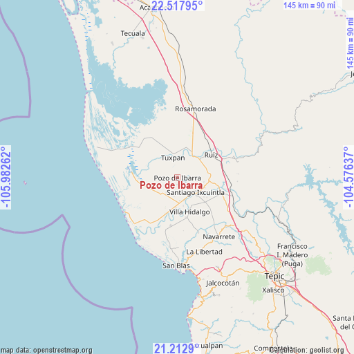
Pozo de Ibarra GPS coordinates[2]
21° 52' 0.912" North, 105° 16' 46.164" West
| Map corner | latitude | longitude |
|---|---|---|
| Upper-left | 22.51795°, | -105.98262° |
| Center: | 21.86692°, | -105.27949° |
| Lower-right: | 21.2129°, | -104.57637° |
| Map W x H: | 145.1×145.1 km | = 90.2×90.2mi |
| max Lat: | 32.7° ⇑16.7% North |
| Pozo de Ibarra: | 21.86692° |
| min Lat: | ⇓83.3% South 14.53588° |
| min Long | Pozo de Ibarra | max Long |
| -117.105° | -105.27949° | -86.73105° |
| W 7.4%⇐ | ⇒92.6% E |
Elevation
Elevation of Pozo de Ibarra is 13 m = 43 ft, and this is 1240.7 m = 4071 ft below average elevation for this country.
| Max E: |
3497 m = 11473 ft | 95.1% |
| Avg. | 1253.7 m = 4113 ft | |
| Pozo de Ibarra | 13 m = 43 ft | |
Min E: |
-1 m = -3 ft | 4.9% |
See also: Mexico elevation on elevation.city.
Geographical zone
Pozo de Ibarra is located in North Torrid zone (between Equator and Tropic of Cancer). Distance of this Northern Tropic circle is 174.5 km =108.4 mi to North.| Distance of | km | miles | from Pozo de Ibarra |
|---|---|---|---|
| North Pole | 7575.7 | 4707.3 | to North |
| Arctic Circle | 4969.8 | 3088.1 | to North |
| Tropic Cancer | 174.5 | 108.4 | to North |
| Equator | 2431.4 | 1510.8 | to South |


Nearby cities:
15 places around Pozo de Ibarra: (largest is in red/bold)
• Amapa
9.6 km =6 mi,  164°
164°
• Cerritos
9.5 km =5.9 mi,  175°
175°
• Colonia Emiliano Zapata
7.5 km =4.7 mi,  124°
124°
• Cuamiles
6.8 km =4.2 mi,  22°
22°
• El Limón
5.1 km =3.2 mi,  236°
236°
• El Puente
3.9 km =2.4 mi, 119°
• Gavilán Grande
7.7 km =4.8 mi,  190°
190°
• La Presa
10.9 km =6.8 mi,  132°
132°
• Paredones (La Punta de la Laguna)
7.4 km =4.6 mi,  85°
85°
• Pozo de Villa
4.7 km =2.9 mi,  214°
214°
• San Vicente
9.5 km =5.9 mi,  348°
348°
• Santiago Ixcuintla
9.5 km =5.9 mi, 129°
• Sentispac
9.7 km =6 mi,  224°
224°
• Tuxpan
8.6 km =5.3 mi, 346°
• Valle Morelos
2.9 km =1.8 mi, 186°
Sources, notices
• [Note1] Compared only with cities in Mexico existing in our database
• [Src1] Map data: © OpenStreetMap contributors (CC-BY-SA)
• [Src2] Other city data from geonames.org with taken over terms of usage.
• [Src3] Geographical zone / Annual Mean Temperature by Robert A. Rohde @ Wikipedia
