San Vicente geodata
San Vicente (Nayarit) is a populated place; located in Mexico in America/Mazatlan (GMT-7) time zone. With population of 4,583 people, there are 2006 cities with bigger population in this country. Compared to other cities in Mexico, 83.8% of cities are located further ↓South; 92.7% of cities are located further →East and 96.3% of cities have higher elevation than San Vicente. Note1


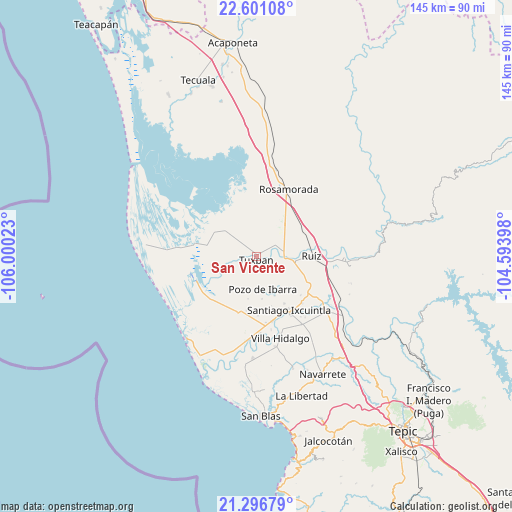
San Vicente GPS coordinates[2]
21° 57' 1.548" North, 105° 17' 49.56" West
| Map corner | latitude | longitude |
|---|---|---|
| Upper-left | 22.60108°, | -106.00023° |
| Center: | 21.95043°, | -105.2971° |
| Lower-right: | 21.29679°, | -104.59398° |
| Map W x H: | 145×145 km | = 90.1×90.1mi |
| max Lat: | 32.7° ⇑16.2% North |
| San Vicente: | 21.95043° |
| min Lat: | ⇓83.8% South 14.53588° |
| min Long | San Vicente | max Long |
| -117.105° | -105.2971° | -86.73105° |
| W 7.3%⇐ | ⇒92.7% E |
Elevation
Elevation of San Vicente is 11 m = 36 ft, and this is 1242.7 m = 4077 ft below average elevation for this country.
| Max E: |
3497 m = 11473 ft | 96.3% |
| Avg. | 1253.7 m = 4113 ft | |
| San Vicente | 11 m = 36 ft | |
Min E: |
-1 m = -3 ft | 3.7% |
See also: Mexico elevation on elevation.city.
Geographical zone
San Vicente is located in North Torrid zone (between Equator and Tropic of Cancer). Distance of this Northern Tropic circle is 165.3 km =102.7 mi to North.| Distance of | km | miles | from San Vicente |
|---|---|---|---|
| North Pole | 7566.4 | 4701.5 | to North |
| Arctic Circle | 4960.5 | 3082.3 | to North |
| Tropic Cancer | 165.3 | 102.7 | to North |
| Equator | 2440.7 | 1516.6 | to South |


Nearby cities:
15 places around San Vicente: (largest is in red/bold)
• Chilapa
11.3 km =7 mi,  37°
37°
• Cuamiles
5.4 km =3.4 mi,  124°
124°
• El Limón
12.3 km =7.6 mi,  191°
191°
• El Puente
12.3 km =7.6 mi,  155°
155°
• El Tamarindo
6.7 km =4.2 mi,  82°
82°
• El Vado de San Pedro
12.1 km =7.5 mi,  91°
91°
• La Boquita
7.2 km =4.5 mi,  319°
319°
• Los Medina
8.5 km =5.3 mi,  313°
313°
• Palma Grande
10.6 km =6.6 mi,  296°
296°
• Paredones (La Punta de la Laguna)
12.7 km =7.9 mi,  133°
133°
• Pericos
12.5 km =7.8 mi,  331°
331°
• Pozo de Ibarra
9.5 km =5.9 mi,  168°
168°
• Tuxpan
0.9 km =0.6 mi, 190°
• Valle Morelos
12.2 km =7.6 mi, 172°
• Vicente Guerrero (El Mogote)
10.3 km =6.4 mi, 304°
Sources, notices
• [Note1] Compared only with cities in Mexico existing in our database
• [Src1] Map data: © OpenStreetMap contributors (CC-BY-SA)
• [Src2] Other city data from geonames.org with taken over terms of usage.
• [Src3] Geographical zone / Annual Mean Temperature by Robert A. Rohde @ Wikipedia
