La Lira geodata
La Lira (Querétaro) is a populated place; located in Mexico in America/Mexico_City (GMT-6) time zone. With population of 6,394 people, there are 1459 cities with bigger population in this country. Compared to other cities in Mexico, 67.2% of cities are located further ↓South; 66% of cities are located further →East and 69.9% of cities have lower elevation than La Lira. Note1


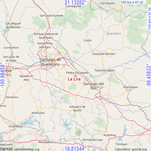
La Lira GPS coordinates[2]
20° 28' 31.944" North, 100° 9' 41.22" West
| Map corner | latitude | longitude |
|---|---|---|
| Upper-left | 21.13282°, | -100.86458° |
| Center: | 20.47554°, | -100.16145° |
| Lower-right: | 19.81544°, | -99.45833° |
| Map W x H: | 146.5×146.5 km | = 91×91mi |
| max Lat: | 32.7° ⇑32.8% North |
| La Lira: | 20.47554° |
| min Lat: | ⇓67.2% South 14.53588° |
| min Long | La Lira | max Long |
| -117.105° | -100.16145° | -86.73105° |
| W 34%⇐ | ⇒66% E |
Elevation
Elevation of La Lira is 1921 m = 6302 ft, and this is 667.3 m = 2189 ft above average elevation for this country.
| Max E: |
3497 m = 11473 ft | 30.1% |
| La Lira | 1921 m 6302 ft | |
| Avg. | 1253.7 m = 4113 ft | |
Min E: |
-1 m = -3 ft | 69.9% |
See also: Mexico elevation on elevation.city.
Geographical zone
La Lira is located in North Torrid zone (between Equator and Tropic of Cancer). Distance of this Northern Tropic circle is 329.3 km =204.6 mi to North.| Distance of | km | miles | from La Lira |
|---|---|---|---|
| North Pole | 7730.4 | 4803.4 | to North |
| Arctic Circle | 5124.5 | 3184.2 | to North |
| Tropic Cancer | 329.3 | 204.6 | to North |
| Equator | 2276.7 | 1414.7 | to South |


Nearby cities:
15 places around La Lira: (largest is in red/bold)
• Ajuchitlancito
5.7 km =3.5 mi,  270°
270°
• Arcila
9 km =5.6 mi,  143°
143°
• Calamanda
8.3 km =5.2 mi,  341°
341°
• El Saúz
4.8 km =3 mi,  87°
87°
• Epigmenio González
8.4 km =5.2 mi,  357°
357°
• Escolasticas
7.4 km =4.6 mi,  224°
224°
• Guadalupe Septién
7.6 km =4.7 mi,  40°
40°
• Ignacio Pérez
7.4 km =4.6 mi,  45°
45°
• La D
4 km =2.5 mi,  167°
167°
• La Palma
5.3 km =3.3 mi,  345°
345°
• Los Álvarez
8.8 km =5.5 mi,  14°
14°
• Pedro Escobedo
3.3 km =2.1 mi, 35°
• Quintanares
6.1 km =3.8 mi,  23°
23°
• San Antonio la D
6 km =3.7 mi,  181°
181°
• San Cirilo
8.1 km =5 mi,  211°
211°
Sources, notices
• [Note1] Compared only with cities in Mexico existing in our database
• [Src1] Map data: © OpenStreetMap contributors (CC-BY-SA)
• [Src2] Other city data from geonames.org with taken over terms of usage.
• [Src3] Geographical zone / Annual Mean Temperature by Robert A. Rohde @ Wikipedia
